August Hike: Sycamore Grove Park
Sunday, August 25, 2019
Date/Time: Sunday, August 25, 2019, 9 am-11 am
Location: Sycamore Grove Park (map), Livermore
Meeting Point: Wetmore Road Entrance Parking lot
Attire: Class B (dress in layers)
Awards: Trail Trekkers Cub Scout Patch/Progressive Hike Award
Parking Fee: $7 per vehicle
Hike Info: Hike info
RSVP: Evite
Contact: Hiking Chair Deva Sundararajan
What to bring:
- binoculars, camera
- layers of clothing appropriate for the weather
- Plenty of water and snacks
Our first 2019-2020 hike will be any easy one at the Sycamore Grove Park. The trail is 4 miles long with hardly any elevation gain. Lion and Tiger scouts are encouraged to participate. This park has a lot of reptiles and if we are lucky and patient we can see some. Near the wet area, we can see some great blue herons - don't forget to look up. Wandering among the Park's sycamores, you may be fortunate enough to see a fox, a bobcat, or perhaps a Red-tailed Hawk soaring overhead. Magpies and Bushtits chatter as you stroll along quiet trails. A quiet hiker can sometimes find deer, rabbits and hares, ground squirrels, mice, lizards, snakes, turtles, frogs, and a variety of birds and insects in the park.
September Hike: Mt. Diablo State Park
Sunday, September 29, 2019
Date: Sunday, September 29, 2019
Time: 10:00 am
Location: Mt. Diablo State Park
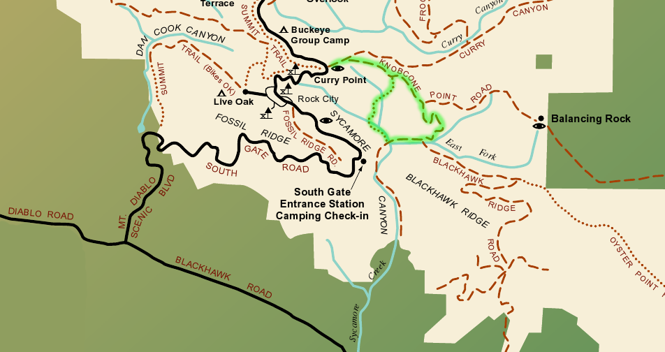
Trailhead: Curry Point, South Gate Road
Attire: Class B
Awards: Highlander Patch Rocker
Entrance Fee: $10 per car
RSVP: Evite
Contact: Hiking Chair Deva Sundararajan
Information: Flyer
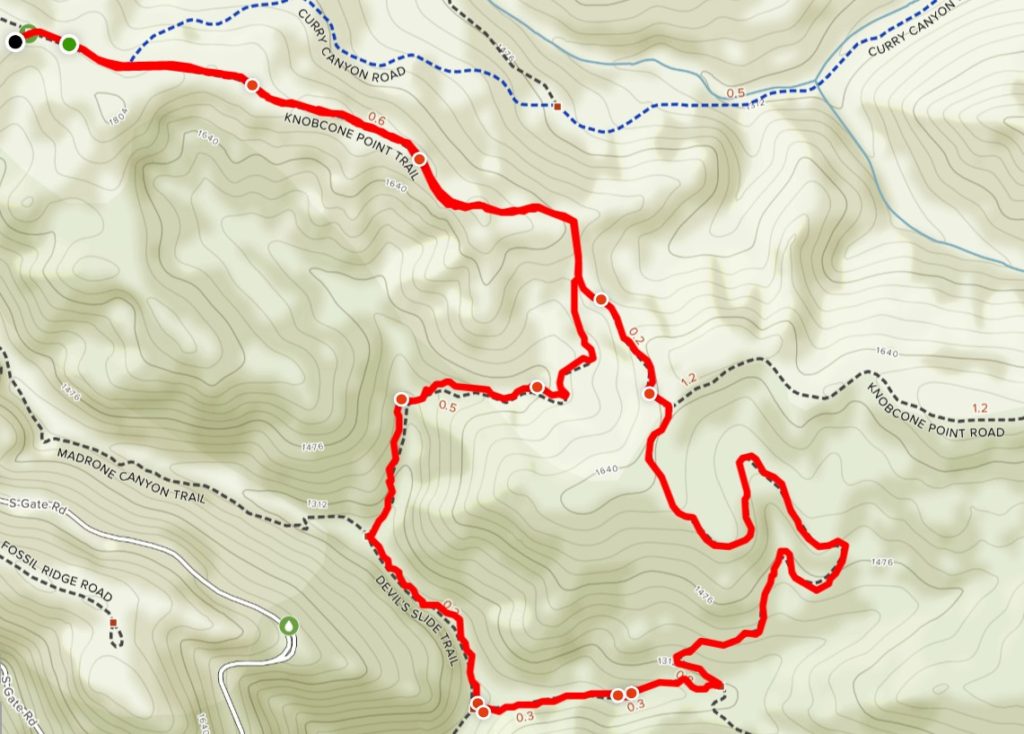
Details: It is an easy 3.3 loop trail with an elevation gain of 700 feet (approx. 1.5 hours). Take the Knobcone Point Road from the parking lot for about 1 mile to Black Hawk Trail. Turn right and continue to Sycamore Creek Road. Turn right again to Devils Slide Trail and turn right. Begin climb out of Sycamore Canyon on this wonderful singletrack trail as it heads back to Knobcone Point Road, where you turn left back to the trailhead. See highlighted trail in map.

What to bring:
- Binoculars, camera
- Layers of clothing – please check weather forecast prior to hike
- Lunch/Snacks/Water
Getting there:
From Crow Canyon Rd continue onto Blackhawk Road. It becomes Diablo Road. Go to Mt. Diablo Scenic Boulevard and turn right. At the Park boundary the road becomes South Gate Road. Continue up the mountain, past the entrance station to just past Rock City. Park in the Curry Point view area on the left.
October Hike: Flag Hill, Sunol Regional Wilderness
Sunday, October 20, 2019

Date: Sunday, October 20, 2019
Time: 10:00 am
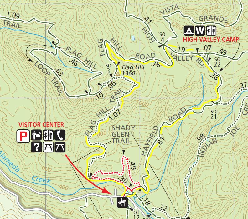
Location: Flag Hill, Sunol Regional Wilderness, Sunol
Meeting Point: Parking lot immediately to the left after the entrance kiosk
Attire: Class B
Awards: Trail Trekkers Cub Scout Patch/Progressive Hike Award
Parking Fee: $5
RSVP: Evite
Trail Map: Download here.
Details: Approximately 3.5-3.8 miles/3 hours long. A moderately strenuous hike will take you to the top of Flag Hill, which is composed of layers of fossil-rich sandstone formed some 13 million years ago. You'll enjoy great views and good opportunities to watch birds and other wildlife. Ambitious hikers may take an optional detour to Indian Joe Cave Rocks. TRAIL MAP

What to bring:
- Binoculars, camera
- Layers of clothing – please check weather forecast prior to hike
- Lunch/Snacks/Water
Getting there:
Go south on I-680 and exit at Calaveras Road/Highway 84 just south of the town of Pleasanton. Turn left onto Calaveras Road and proceed to Geary Road, which leads directly into the park.
November Hike: Redwood Creek Regional Park
Sunday, November 17, 2019
Date: Sunday, November 17, 2019
Time: 11:00 am
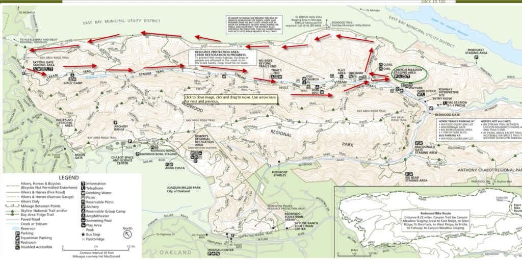
Location: Redwood Creek, East Ridge and Stream Trails, Redwood Regional Park, Oakland
Meeting Point: Canyon Meadow Staging Area
Distance: 6 miles (2 hours)
Attire: Class B
Awards: Trail Trekkers Cub Scout Patch/Progressive Hike Award
RSVP: Here
Parking Fee: $5
Information: Flyer
Contact: Hiking Chair
What to bring:
- Binoculars, camera
- Layers of clothing – please check weather forecast prior to hike
- Lunch/Snacks/Water
Details: This hike will take place in the beautiful Redwood Regional Park in Oakland. This will be a six mile hike (approx. 2 hours with 950 feet in elevation gain) that will reward its hikers with great views of the San Leandro Reservoir and the surrounding hills.
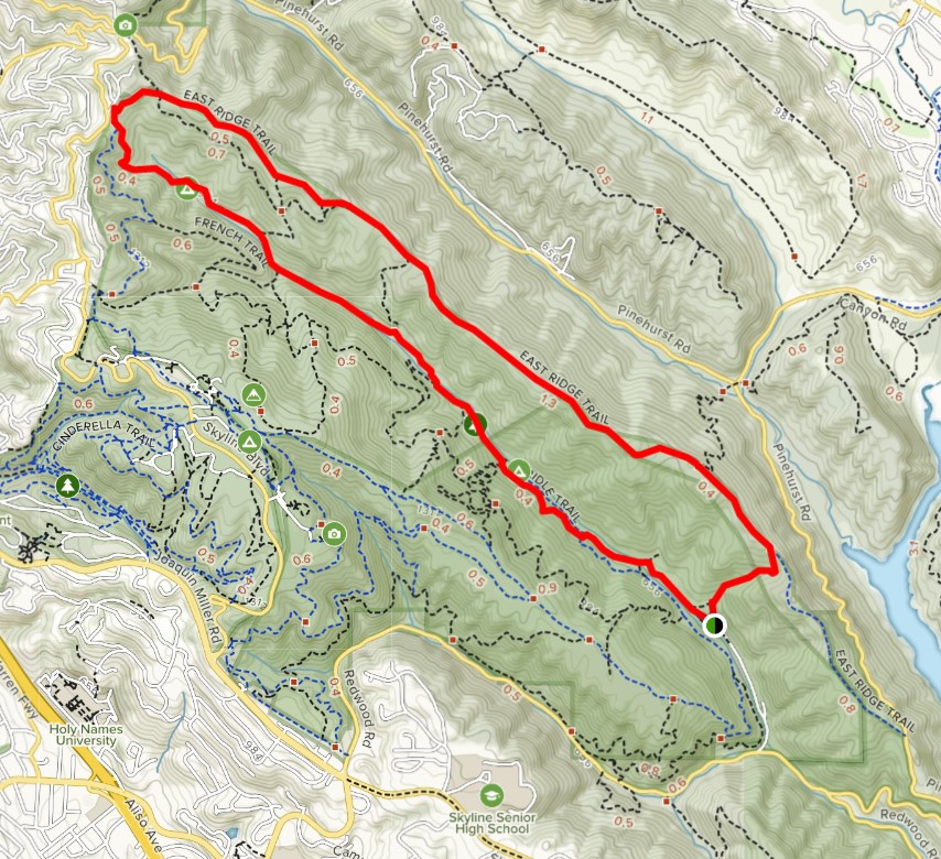

Due to the distance of the hike we recommend all hikers come prepared with plenty of snacks, water and a lunch to enjoy during our break. We will meet at the Canyon Meadow Staging Area and head to the Canyon View Trail. We will then go along the East Ridge until we reach the Skyline Gate. At this time we will have a break and can refill our water bottles or use the restrooms. We will head down the Stream Trail to Mill Site or Fern Hut where we can stop for lunch. If we are lucky the stream will be full and get to see a few of the cascades. We are also hoping to see a special treat: ladybug hibernation. Thousands of ladybugs have been converging in clusters along the Stream Trail between Prince Road and Tres Sendes. Another gathering can be found midway on the French Trail between Tres Sendes and West Ridge Trail (Mother Nature willing, of course).

January Hike: Rodeo Lagoon, Marin Headlands (GGNRA)

Date: On your own
Time: With your family or den
Location: Rodeo Lagoon, Sausalito
Meeting Point: Marin Headlands Visitor Center
Attire: Class B
Awards: Trail Trekkers Cub Scout Patch/Progressive Hike Award. Scouts can also choose to become Junior Rangers.
Fees: None (bridge toll only)
RSVP:
Contact: Hiking Chair Deva Sundararajan
What to bring:
- binoculars, camera
- layers of clothing – please check weather forecast prior to hike
- Lunch/Snacks/Water – Please note that there are NO food vendors in the Marin Headlands
Details
You can begin at the Marin Headlands Visitor Center. Scouts who choose to becoming junior rangers can get Junior Ranger booklets from the Visitor Center (if it is open).
The start of the Rodeo Lagoon Trail Loop is at the picnic area. First cross the footbridge, heading north towards Bunker Road. Go left towards the ocean, following the path around the lagoon. Return to Rodeo Lagoon Loop and continue to follow the path back to the picnic area
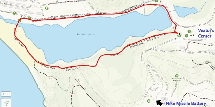
Following the hike, if it is open, you can drive up to the Nike Missile Site site to learn about some of our country's history. This is usually open Saturdays from 12:30 - 3:30 PM, but has been listed as closed in the past months due to COVID. Double check the GGNRA website beforehand.

If it is open, families may also chose to visit the Marine Mammal Center on their own. This too has been listed as closed in the past months due to COVID. Double check their website beforehand.
Don't forget to bring a lunch, snacks and plenty of water. There are no food vendors at this location. Wear appropriate clothes since the weather may change rapidly.
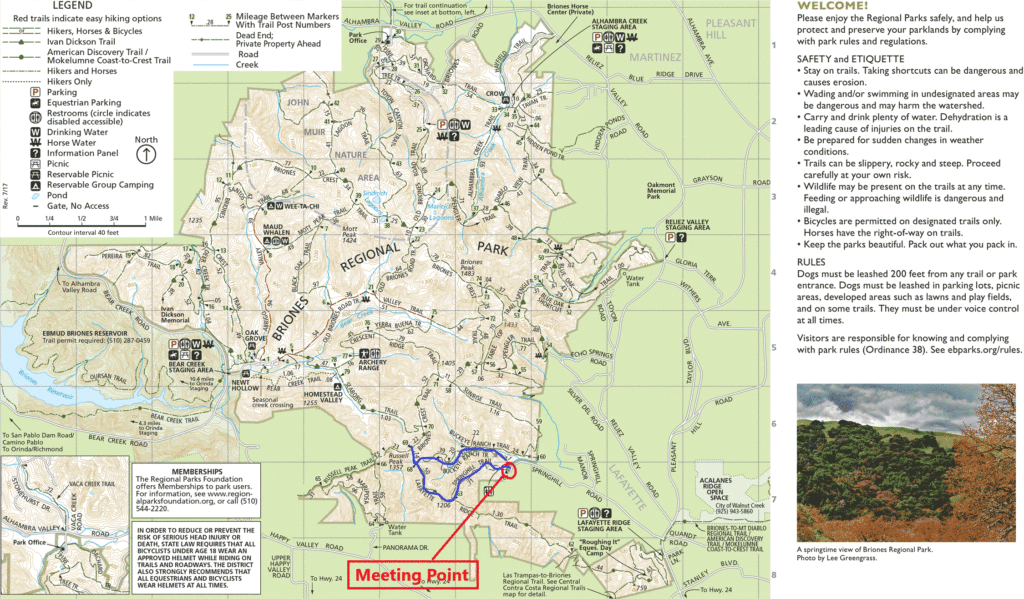
January Hike: Briones Regional Park
January 26, 2020
Date: Sunday, January 26, 2020
Time: 2 pm
Location: Briones Regional Park
Attire: Class B
Award: Highlander Briones rocker patch
Fees: $3 per vehicle (when kiosk is attended)
Meeting Point: Bear Creek Staging Area
Contact: Hiking Chair Sundararajan
RSVP: Evite.
Distance: 2.2 Miles Elevation: 613 feet Download Map.
How to get there
Bear Creek Staging Area: From Highway 24, take the Happy Valley Road exit and go north. Turn right at Bear Creek Road, take the 1st right onto Briones Valley Rd (37.925776, -122.162733).
Parking
Make an immediate left after the kiosk and park in the lower lot.
Details:


