Rock Climbing at REI Concord
Date/Time:Friday, January 13th or 20th, 6:30-7:30pm
Location: REI Concord, 1975 Diamond Blvd Ste B100 (The Willows Shopping Center), Concord, CA 94520
Cost: Free
Attire: Class B & closed toe shoes
Capacity: 15 youths per session
Signup: Signup genius
Pack 1776,
Our January hiking event will take place indoor at REI Concord. The scouts will climb the rock wall and learn a few things about Leave No Trace. No experience necessary. Choose from the January 13th or 20th session. Each session accomodates up to 15 children. The event is free and signup is open to scouts only for now. Remaining spots will open to siblings in a week.
Wear Class B and closed toe shoes. A signed liability release form is required before participating in the activity. Please complete in advance and bring it to the event.
Thanks,
Stella Lei
December Hike – Coyote Hills

Date/Time: Sunday, December 11, 2011 1:00pm - 3:00pm
Location: Coyote Hills Regional Park (Meet at Visitor Center)
Cost: $5 parking
Attire: Class B uniform
Award: Participating scout receives a Coyote Hills patch, and a Trail Trekkers patch if he doesn't have one already.
Pack 1776,
Our next hike is coming up on Sunday, December 11th. Click here for detail. All scouts and siblings welcome. Sign up not necessary. Contact hiking chair Bernard Kiriakos if you have questions.
Thanks,
Stella
Hoot Owl Night Hike
Update 09/06: Thank you again for the overwhelming response. We have more signed up than we can accommodate at this time. The waiting list is now closed. We will look into running this hike again in the near future.
Update 09/05: Thank you for the quick response. The hike is now full. New sign ups will be placed on the waiting list.

Date/Time: Friday, September 23rd, 6:45pm - 8:45pm
Location: Sycamore Grove Park in Livermore
Cost: $10 per person. Pay by September 9th to hold your spots.
Attire: Class B uniform
Award: Participating scout will receive a Hoot Owl patch, and a Trail Trekkers patch if he doesn't have one already.
Meeting Location: Nature Area Entrance (see directions below)
Note: Scout only, no siblings. One parent per family.
Must read: Hoot Owl Guidelines, Directions, Hike Detail
Pack 1776,
Welcome to the first hike of the new scout year. This is a special hike for a few reasons. It is a night hike. It is a ranger led hike. It is a fee based hike ($10 per person). It is limited to 20 people only (limit is set by hoot owl program).
This hike is limited to scouts only - No siblings are allowed. The parent must accompany their scout(s).
Please reply quickly to the email invitation as seats are limited. (No other evite will be sent.)
The hike lasts one and a half to two hours and begins with a ranger-led introduction to nocturnal animals and adaptations of nighttime critters, followed by an easy hike of one to one and a half miles.
Everyone is expected to use their night vision during the program, so please leave your flashlights at home.
Bernard Kiriakos
Hiking Chair
April Hike – Joseph D. Grant County Park
/images/findapark_small_img/joseph_grant.jpg) Date: Saturday, April 30, 2011
Date: Saturday, April 30, 2011
Time: 1:30pm
Location: Joseph D. Grant County Park - 18405 Mt. Hamilton Rd., San Jose, CA 95140
Pack 1776,
- Next hike is on April 30th
- It will coincide with our camping
- You can do the hike even if you are not camping
- The hike is located at Joseph D. Grant County Park - 18405 Mt. Hamilton Rd., San Jose, CA 95140,
- Travel to the park by taking Highway 101 or Highway 680 to Alum Rock Avenue eastbound in San Jose.
- Turn right onto Mt. Hamilton Road and travel eight miles to reach the park entrance.
- Park Office: (408) 274-6121
- Start time: 1:30 PM
- Meet at the camping ground
- Dress in layers
- Bring water
- Bring a snack
- Wear long pants/sleeves (preferable)
- This is a special hike that will focus on Education (recognizing poisonous plants, using a compass with a map, how to leave no trace behind)
- Cub scouts who complete the course and the hike will earn a belt loop and a pin.
For additional information, please consult this document.
Bernard, hiking chair
March Hike – Pleasanton Ridge
 Date: Saturday, March 5, 2011
Time: 1:30pm - 4:00pm (Meet in the Parking lot at 1:30 PM sharp.)
Location: Pleasanton Ridge Regional Park
Note: Large parking lots, with a few additional spaces before the gate. No entrance or parking fees.
This 5.9 mile loop climbs through oaks and grassland to a series of bare rolling hills, then drops back to the trailhead. Trailhead elevation is about 260 feet. The featured hike climbs to about 1430 feet. Most of the trails are moderate, although there's a bit of steep up and down on the ridgeline -- total elevation change is about 1200 feet.
[stextbox id="info" caption="Hike Statistics" align="center"]Distance: 5.9 miles
Time: 2.5 hours
Trail surfaces: Dirt fire roads and trails.
Be sure to read: Hike info and area info[/stextbox] [stextbox id="info" caption="What to Bring" align="center"]Wear Boots. Bring water and snacks. Dress in layers.
[/stextbox] [stextbox id="info" caption="Directions" align="center"]From Interstate 680 exit Sunol Boulevard/Castlewood Drive (exit 25).
Head west on Castlewood Drive and where the road splits stay to the right on Castlewood.
At the stop sign, turn left onto Foothill Road and drive about 1.6 miles to the trailhead on the right side of the road.
GPS Coordinates for trailhead:Latitude 37°36'52.83"N, Longitude 121°52'54.88"W
View Larger Map[/stextbox]
Forest Conservation Days
Update 3/26/2011: This event is ON, rain or shine, today and tomorrow at 1:30pm.
Some parents inquired about the event on Thursday during our pack meeting. It is definitely on. It is not often that we can hike and learn from a forester. The Scout will earn a pin and I think that this event will help them with Science at school.
Bernard
Date: Two sessions to choose from:
----- Saturday March 26, 2011 1:30-3:30pm
----- Sunday, March 27, 2011 1:30-3:30pm
Location: Sanborn Park, Saratoga, CA (directions)
Cost: Free, except for a $6 park entrance fee
RSVP: Indicate your session selection on evite by this Thursday February 17, 2011
Pack 1776 will be joining the Santa Clara County Parks and Recreation Department and the Northern California Society of American Foresters in the 2011 Forest Conservation Days (FCD) celebration to be held on March 26 and 27.
We will go on a 2-3 hour interactive, hands-on hike with a forester through the redwood forest and the oak woodlands of Sanborn Park. Included will be tree identification, and instruction/activities on geology, soils, wildlife biology, native culture, fire fighting, forest products, demonstration of a vintage 1882 Steam Donkey, and more!
This is a great opportunity to fulfill requirements of the Webelos forester and geologist activity pins, Bear elective #15 (water & soil conservation), Wolf elective #18 (outdoor adventure), belt loops and pins for geology and wildlife conservation, etc. Cloth patches commemorating FCD 2011 will be available for participating scouts. More information on FCD in this flyer and at this website.
Siblings welcome. Reserve your spots via evite by 2/17/2011, that is this Thursday!! Send inquiries to Hiking Chair Bernard Kiriakos.
February Hike – Lafayette Reservoir Recreation Area

Date: Saturday, February 5, 2011
Time: 1:00pm - 3:00pm
Location: Lafayette Reservoir Recreation Area
Parking: $6 all day in the lot or metered parking (0.25$ for 15 minutes)
This 4.7 mile loop hike is moderate, with a total elevation change of about 700 feet. There are two trails at the reservoir. We will go on Lakeside which is paved, nearly level and easy. Coffee & hot chocolate at Starbucks Lafayette after the hike: 3540 Mt. Diablo Blvd. Lafayette
[stextbox id="info" caption="Hike Statistics" align="center"]Distance: 4.7 miles
Time: 2 hours
Trail surfaces: Dirt fire roads.
Be sure to read: Hike info and area info[/stextbox] [stextbox id="info" caption="What to Bring" align="center"]Rain jacket (or umbrella), boots, water, snacks, dress in layers[/stextbox] [stextbox id="info" caption="Directions" align="center"]From CA 24 in Contra Costa County, exit Mount Diablo Boulevard/Acalanes Road/Upper Happy Valley Road (exit 11). Drive east on Mount Diablo Boulevard about 1 mile, then turn right at the Lafayette Reservoir sign. Stay to the right, drive uphill on the one way street, then bear left, toward day use parking.
View Larger Map [/stextbox]
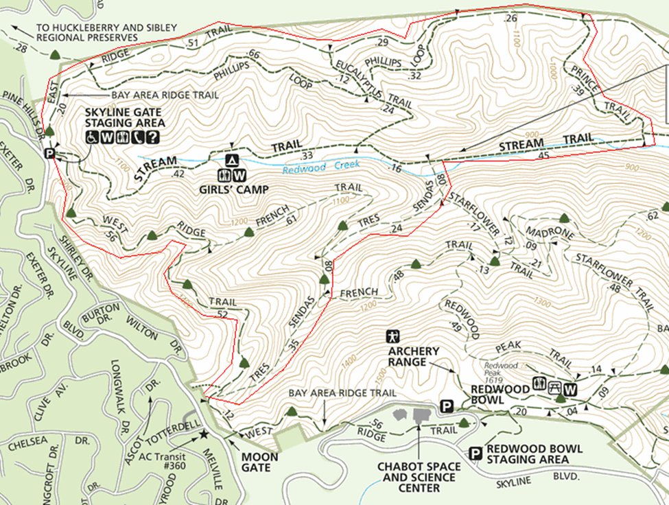
January Hike – Redwood Regional Park
 Date: Saturday, January 22, 2011
Time: 12:00pm - 2:00pm
Location: Redwood Regional Park (map)
This is an easy 3.7 mile loop hike. Trailhead elevation is around 1255 feet. The featured hike climbs easily to about 1385 feet, drops to about 780 feet, then regains the lost elevation on the way back to the trailhead -- total elevation change is about 700 feet. The ascending/descending trails are moderate-steep, but short.
[stextbox id="info" caption="Hike Statistics" align="center"]Distance: 3.7 miles
Time: 2 hours
Trail surfaces: Dirt fire roads and trails.
Be sure to read: Hike info and park map[/stextbox] [stextbox id="info" caption="Directions" align="center"]From CA 24 in Contra Costa County, exit Fish Ranch Road
Drive uphill on Fish Ranch Road about 1 mile,
then turn left onto Grizzly Peak Blvd.
Drive 2.4 miles, then turn left onto Skyline Boulevard.
Drive 2 miles on Skyline Boulevard, then turn left into the parking lot.
<< The park is about 3 miles from the Chabot Space Center>>[/stextbox] [stextbox id="info" caption="What to Bring" align="center"]Long pants
Boots: Canyons are often muddy in winter
Dress in Layers
Snack
Water[/stextbox] [stextbox id="info" caption="The Hike" align="center"]
- Walk to the south corner of the parking lot (the opposite end from the portable toilets),
- look for the signed West Ridge Trail.
- At 0.49 mile, French Trail sets out downhill on the left side
- Continue straight on West Ridge.
- At 0.96 mile, at a signed junction, Tres Sendas Trail begins on the left.
- Turn Left on Tres Sendas
- At 1.35 miles, Tres Sendas meets French Trail at a signed junction.
- Continue straight on Tres Sendas.
The two trails run together, until French breaks off at a signed junction at 1.43 miles and heads back uphill. - Continue on Tres Sendas.
- At a signed junction at about 1.67 miles, Star Flower Trail departs uphill on the right.
- Continue downhill on Tres Sendas.
- Just past this junction, you'll reach Redwood Creek (fenced)
- Follow the path as it crosses the creek and then ends at a signed junction with the Stream Trail at 1.75 miles.
- Turn right onto Stream Trail.
- At 2.20 miles, look for the start of Prince Road to the left at a signed junction.
- Turn left onto Prince Road.
Head uphill, and at 2.41 miles, the trail ends at a signed junction with East Ridge Trail. Turn left onto East Ridge Trail. - At a signed junction at 2.66 miles. East Ridge Trail continues straight, and Phillips Loop Trail breaks off to the left. B
- Turn left onto Phillips Loop Trail.
At 2.96 miles, Phillips Loop Trail crosses Eucalyptus Trail at a signed junction. - Continue straight on Phillips Loop Trail.
Phillips Loop Trail ends at a signed junction with East Ridge Trail at 3.58 miles. - Turn left onto East Ridge Trail.
Continue straight on East Ridge Trail. - East Ridge Trail ends at the parking lot.
Las Trampas Hike Wrap-Up
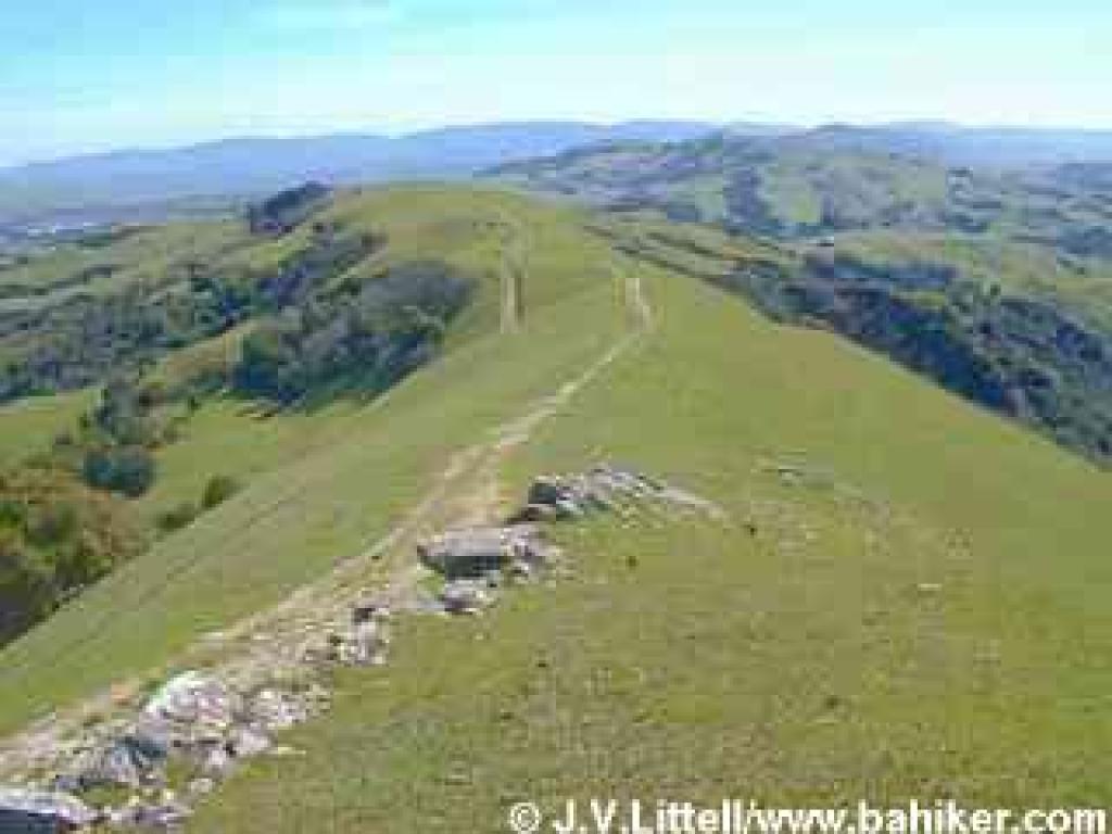 Las Trampas hike was an arduous and annoying hike due to the excessive mud. The mud slowed us down, yet the Scouts finished this hike in 2 hours and 20 minutes a record hike when you consider that the recommended time for this tough 4.6 mile hike is 3 hours!
I would like to congratulate the following Scouts for completing the hike:
* Austin S - Tiger (!!!!)
* Morgan J - Wolf
* Andre B - Webelos I
* Jacob K - Bear
Jacob also invited two friends: Josey J, Webelos & Jerry J, Bear.
* Alex also joined the hike with Cubmaster Macey. They were far behind us and decided to take a long detour ending the hike at 5:00 PM.
I am totally impressed by all the Scouts who took on the challenge today.
Check out the pictures at the Pack photo site.
Bernard
Hiking Chair
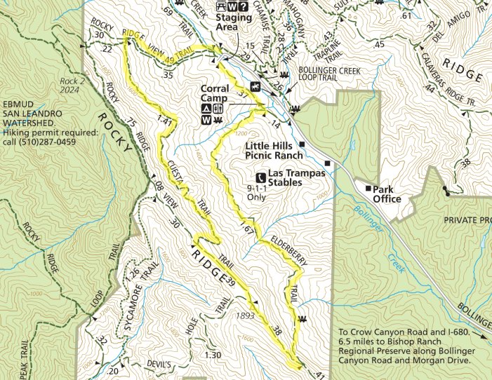
December Hike – Las Trampas Regional Wilderness
Updated 12/9: Please note the time change.
 Date: Sunday, December 12, 2010
Time: 1:45pm - 4:00pm
Location: Las Trampas Regional Wilderness
This 4.6 mile loop hike is moderate. Trailhead elevation is about 1040 feet. The featured hike climbs to about 1880 feet and then descends back to the trailhead. There are numerous short, somewhat steep ascents and descents, and the total elevation change is about 900 feet. It will be an exciting challenge for Cub Scouts (and adult partners!)
[stextbox id="info" caption="Hike Statistics" align="center"]Distance: 4.6 miles
Time: 3 hours
Trail surfaces: Dirt trails and one paved fire road.
Be sure to read: Hike info and park map[/stextbox] [stextbox id="info" caption="Directions" align="center"]Follow Crow Canyon Road, drive west pass I-680 for about 1 mile, then turn right (north) onto Bollinger Canyon Road. Continue about 4.5 miles to the trailhead at the end of the road. (map)[/stextbox] [stextbox id="info" caption="What to Bring" align="center"]Water, snack (granola bars, trail mix, fruit), sun screen.
Binoculars, camera, layer your clothes.[/stextbox] [stextbox id="alert" caption="Note" align="center"]Please arrive by 1:45 PM as we plan to start prompty at 2 PM![/stextbox] 