Aug 13: August Pack Hike!
Date/Time: Sunday, August 13, 2023, at 9am
Location: Little Yosemite — Sunol Regional Wilderness
Meeting Point: Parking lot immediately to the left after the entrance kiosk - 1895 Geary Road, Sunol, CA 94586
https://www.ebparks.org/parks/sunol
[ RSVP ]
Fee: $5 parking fee / $2 per dog
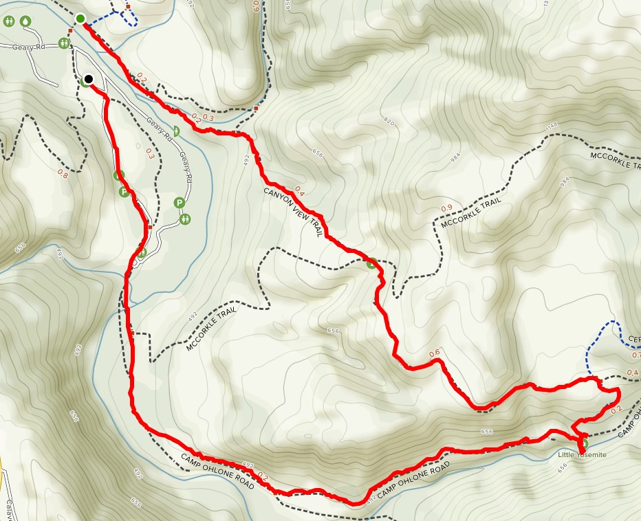
Distance / elevation: 4.8-mile loop / 524 ft
Difficulty: Easy to Moderate / Recommended for Tigers to Webelos
Trail map: https://b846b6.p3cdn1.secureserver.net/wp-content/uploads/2019/12/little-yosemite-map.jpg
Awards: Trail Trekkers Cub Scout Patch // Progressive Hike Award https://ggacbsa.org/hiking-programs/
Contact: Hiking Co-Chair Murali Kattimani / 408-250-0542
What to wear - Class B and dress in layers, incl. windbreaker - Approved face covering - Sturdy closed toe shoes - Hat + sunscreen
What to bring - binoculars, camera - plenty of water and snacks - map
Directions
Drive south on I-680 and exit at Calaveras Road/Highway 84, just south of Pleasanton. Turn left onto Calaveras Road and proceed to Geary Road, which leads directly into the park.
Important
Trails can be quite steep
Watch for poison oak on narrow sections of trail
Rattlesnakes may be in rocky areas — careful where you place hands and feet
No swimming allowed in Alameda Creek in the Little Yosemite area
There will be cattle at Sunol -- give them plenty of distance
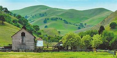
The hike
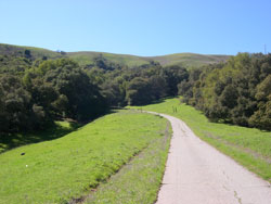
Little Yosemite is located in Sunol Regional Wilderness Park in Sunol, CA. Little Yosemite is a scenic gorge on Alameda Creek about two miles upstream from park headquarters. It is an especially attractive portion of this creek. See gorgeous waterfalls and pools after series of rain storms or season.
The trail
The Canyon View Trail is an excellent hike for Cub Scouts and a great way to get to Little Yosemite. The trail begins near the Visitor Center, at the bridge that crosses the creek. After crossing the bridge, turn right and head upstream. The Canyon View trail is well marked. The trail goes up a ridge or two, and along the hillsides that border the creek. Along the way, you'll see some nice views of the creek and canyon. About halfway, the trail drops down into Jacobs’s Valley. Stay on the trail until you get to Cerro Este Road and turn right (toward the creek) and follow the road to Little Yosemite. When you get to the outhouse on Camp Ohlone Road, cross the road where you will find a path that will take you down the very steep sides of the creek's banks, to the ancient piles of boulders called Little Yosemite. This is a perfect place for scouts to study rocks and have lunch. Remember collecting specimens is not allowed. Watch for poison oak. Hikers can return the same way, or via the Ohlone Road for a different view of the park. To return via Ohlone Road, simply climb back up the bank to the road (stay on the trail), downhill. Notice how different the vegetation is here by Alameda Creek, compared to the Canyon View Trail. Eventually you will cross a bridge, pass a gate and find yourself in a remote parking area. Stay on the paved road all the way back to the Visitor Center.
The history
The original inhabitants in the Sunol Valley were the Ohlone Indians and reminders of them can be seen in the acorn pounding bedrock mortars found in the park. For the past half century, the land known today as Sunol Regional Wilderness was used almost exclusively as ranch land. Alameda Creek is the county's largest stream and hosts an attractive community of trees including alder, willow, sycamore and bay laurel. The nearby valleys abound with coastal live oak, blue and valley oak, elderberry, madrone, and California buckeye. During spring, the hills come alive with a variety of colorful wildflowers. A wildflower identification kit may be checked out at the visitor center.
For all in-person pack or den events and activities, please follow the SRVUSD COVID guidelines. If you or your Scout are sick, are experiencing COVID-like or flu symptoms, or may have been exposed to COVID-19, please stay home and stay safe.
May Hike: Black Diamond Hills
Date: Sunday, May 2, 2021

Time: 8:30 am
Location: Black Diamond Mines Regional Preserve
Meeting Point: Parking lot ~ a mile beyond the visitor center (37°57'33.9"N, 121°51'46.8"W)
Attire: Class A or B
Awards: Highlander Black Diamond rocker patch
Parking Fee: $5
Distance: 3.5 miles (2-3 hours)
Information: Map & Trail Directions
MANDATORY FACE COVERINGS AND SOCIAL DISTANCING REQUIRED
We will meet at the parking lot that is a approximately a mile beyond the visitor center.
(GPS Coordinates: 37°57'33.9"N, 121°51'46.8"W)
We will hike up the hill to the Rose Hill Cemetery and then backtrack to the Black Diamond Trail to the trails above the mine. The trails will pass by some of the mining features that the Scouts can explore. This hike does include some steep climbs. Please dress appropriately for the weather and bring plenty of water.
March Hike: Little Yosemite

- When: On your own!
- Location: Little Yosemite, Sunol Regional Wilderness, Sunol
- Starting Point: Visitor Center/Parking lot, 1895 Geary Rd, Sunol, CA 94586; Corner of parking lot right by the trailhead.
- Attire: Class B
- Awards: Trail Trekkers Hiking Patch
- Fees: Park Entrance Fees - $5.00
- Total Distance: 2.5mi - 3.0mi
- Trail Surfaces: Fire roads and dirt trails
- Must read: Hike info
- Directions from Coyote Creek Elementary School
Pack 1776 will take advantage of the milder weather to hike Little Yosemite in Sunol Regional Wilderness. The scenic trail runs parallel to a creek and offers some of the most impressive views in bay area. Frequent rain in winter may provide opportunity to view beautiful waterfall in Sunol.
February Hike: Redwood Creek Regional Park
Lady Bug Migration Time!

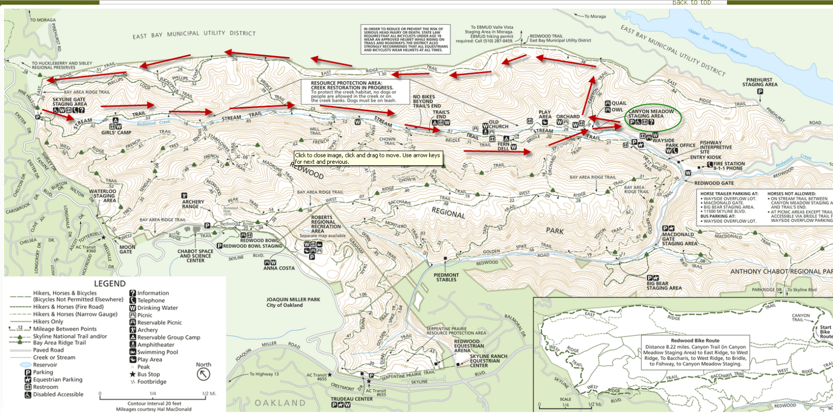
Location:Redwood Creek, East Ridge and Stream Trails, Redwood Regional Park, Oakland
Starting Point: Canyon Meadow Staging Area
Distance: 6 miles (2 hours)
Attire: Class B
Awards:Trail Trekkers Cub Scout Patch/Progressive Hike Award
Parking Fee: $5
Alltrails Map: Download Here
Due to the distance of the hike it is recommended that all hikers come prepared with plenty of snacks, water and a lunch to enjoy during our break. Start at the Canyon Meadow Staging Area and head to the Canyon View Trail. Then go along the East Ridge until you reach the Skyline Gate. At this time you can take a break and refill your water bottles or use the restrooms. Then head down the Stream Trail to Mill Site or Fern Hut where you can stop for lunch. If you are lucky the stream will be full and get to see a few of the cascades.
We are hoping to see a special treat: ladybug hibernation. Thousands of ladybugs have been converging in clusters along the Stream Trail between Prince Road and Tres Sendes. Another gathering can be found midway on the French Trail between Tres Sendes and West Ridge Trail (Mother Nature willing, of course).
January Hike II: Sycamore Grove
Date/Time: With you family.
Location: Sycamore Grove Park (map), Livermore
Meeting Point: Wetmore Road Entrance Parking lot
Attire: Class B (dress in layers)
Awards: Trail Trekkers Cub Scout Patch/Progressive Hike Award
Parking Fee: $7 per vehicle
Hike Info: Hike info
RSVP: Do on your own
For those of you who wish to hike closer to home, an easy one is at the Sycamore Grove Park. The trail is 4 miles long with hardly any elevation gain. Lion and Tiger scouts are encouraged to participate. This park has a lot of reptiles. Near the wet area, you may see some great blue herons - don't forget to look up. Wandering among the park's sycamores, you may be fortunate enough to see a fox, a bobcat, or perhaps a Red-tailed Hawk soaring overhead. Magpies and Bushtits chatter as you stroll along quiet trails. A quiet hiker can sometimes find deer, rabbits and hares, ground squirrels, mice, lizards, snakes, turtles, frogs, and a variety of birds and insects in the park.
What to bring:
- binoculars, camera
- layers of clothing appropriate for the weather
- Plenty of water and snacks
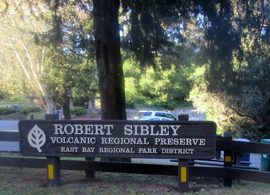
November Hike: Sibley Volcanic Trail
- Date: November - on your own!
- Time: Do as a den or family.
- Trail: Round Top, Volcanic and Skyline Trail Loop
- Location: Sibley Volcanic Regional Preserve
- Meeting Point: Sibley Main Staging Parking Lot
- Who can come: Everyone!
- RSVP: Do as a den or family.
- FACE COVERINGS REQUIRED. HIKERS NEED TO STAY IN THEIR FAMILY POD WHEN HIKING.
- This hike fulfills the Geology Hike requirement for those working on SuperNova.
- AllTrails Map
- EBRPD Map
November's pack hike of the month will be the Sibley Volcanic Trail, located in the Oakland Hills. Since this area has a small parking lot and given the large turn out we had last month, we'd like to conduct this hike on a smaller level. So, get outdoors as a family or with your den to do this hike. Burn off some of the that Thanksgiving turkey on this cool hike! Send a photo of your scout at the Trailhead and we'll send he or she their patch (note this is not a TrailTrekker or Highlander patch hike) in the next pack delivery.
The Volcanic Trail was once a quarry haul road. This contains most of the stops on a self-guided volcanic tour. The hike is about 3.5 miles long. Did you know we have a volcano in our backyard at Sibley Volcanic Regional Preserve? Originally called Round Top Park, Sibley shares with Temescal and Tilden the distinction of being one of the East Bay Regional Park District's original parks. The preserve was later named in honor of Robert Sibley, who helped found the District and served for 10 years on its board of directors.
What to Bring:
- Facecovering
- Plenty of water and snacks
- Layers of clothing appropriate for the weather
- Binoculars, camera (optional)
October Hike: Las Trampas Regional Wilderness
- Date: Sunday, October 18, 2020
- Time: 2:00 p.m.
- Location: Las Trampas Regional Wilderness
- Meeting Point: Parking lot at the end of Bollinger Canyon Road, San Ramon, CA
- Attire: Class B
- Who can come: Everyone!
- RSVP: Evite
- FACE COVERINGS REQUIRED. HIKERS NEED TO STAY IN THEIR FAMILY POD WHEN HIKING.
- This is a TrailTrekker Patch Hike.
- Trail Map
Directions: From Highway 680: Take the Crow Canyon Road exit. Drive west on Crow Canyon for about 1 mile, then turn right (north) onto Bollinger Canyon Road. Continue about 4.5 miles to the trailhead at the end of the road. Alternatively, drive west on Bollinger until it ends at the park. It is about 10 miles from school on Bollinger Canyon Road. Meet at the parking lot at the end of the road inside the park.
Trail: Bollinger Creek Loop trail. It is a very nice nearly flat 1.5 Mile trail. It should take less than 1 hour to complete. Is is an easy hike for our younger scouts.
What to Bring:
- Facecovering
- Plenty of water and snacks
- Layers of clothing appropriate for the weather
- Binoculars, camera (optional)
Overview:
Las Trampas (Spanish for the traps) has two distinct areas, each with its own personality. Rocky Ridge, on the west side of the valley, is known for views in all directions, unusual rocks and green rolling hills lightly forested with California bays, oaks and maples. The wildflower display on the hills just off the ridgeline is an east bay favorite. The Las Trampas Ridge, to the east, is quite different, featuring a plant community dominated by chamise with other chaparral plants such as manzanitas and coyote brush.
April Hike: Little Yosemite, Sunol Regional Wilderness – POSTPONED
April 19, 2020
- Date:
April 19, 2020 - Time: 10:00 AM
- Location: Little Yosemite, Sunol Regional Wilderness, Sunol
- Meeting Point: Visitor Center/Parking lot, 1895 Geary Rd, Sunol, CA 94586; Corner of parking lot right by the trailhead.
- Attire: Class B
- Awards: Trail Trekkers Cub Scout Patch/Progressive Hike Award.
- Fees: Park Entrance Fees - $5.00
- Total Distance: 2.5mi - 3.0mi
- Trail Surfaces: Fire roads and dirt trails
- Must read: Hike info
- Directions from Coyote Creek Elementary School
- Contact: Hiking Chair – Deva Sundararajan
- RSVP: Evite to come
Pack 1776 will take advantage of the milder weather to hike Little Yosemite in Sunol Regional Wilderness. The scenic trail runs parallel to a creek and offers some of the most impressive views in bay area. Frequent rain in winter may provide opportunity to view beautiful waterfall in Sunol.

Direction from I-680S (Bollinger Canyon Exit):
Follow I-680 S to CA-84 E in Sunol. Take exit 21A from I-680 S. 12 min (13.0 mi). Take Calaveras Rd and Geary Rd to Ohlone Rd, 19 min (7.8 mi). Merge onto CA-84 E, (0.1 mi). Turn left onto Calaveras Rd (signs for I-680 S) (4.3 mi). Turn left onto Geary Rd (2.3 mi), Geary Rd turns slightly right and becomes Ohlone Rd. Destination will be on the left.
May Hike: Windemere Ridge Trail
- Date:
Sunday, May 17, 2020DO THIS ON YOUR OWN TIMETABLE - Time:
- Location: Windemere Ridge Trail
- Distance: 2.1 miles
- Meeting Point: Dougherty Station Parking Lot, 17017 Bollinger Canyon Road, San Ramon, CA 94582
- Attire: Class B
- RSVP: THIS IS NO LONGER A PACK EVENT DUE TO THE SHELTER IN PLACE RESTRICTIONS. PLEASE HAVE A GREAT TIME EXPLORING THIS NEARBY TRAIL AS A FAMILY!
Directions: The Windemere Ridge Trail begins at the intersection of Bollinger Canyon Rd and E. Branch Parkway. There is ample parking in Dougherty Station Library. Walk across intersection to access trail.
Trail: The Windemere Ridge Trail is a 2.1 up and back course that begins across the street from the Windemere Ranch Middle School on East Branch Parkway near Bollinger Canyon Road. The trail is concrete and is a cattle grazing area. After an initial steep incline, the trail follows along the rolling hills of the Dougherty area with beautiful views of the valley. The Windemere Ridge Trail is great for walking, and running. The trail is great for young kids to acclimatize to hiking. Trail info on San Ramon
July Hike: Wildcat Peak, Tilden Regional Park, Berkeley
Sunday, July 19, 2020 DO ON YOUR OWN. NOTE PARKING AREAS MAY BE CLOSED SO CHECK THE TILDEN PARK WEBSITE
- Date: On your own.
- Time: On your own.
- Location: Wildcat Peak, Tilden Nature Study Area, Tilden Regional Park, Berkeley
- Meeting Point: Parking Lot of Environmental Education Center at 600 Canon Dr, Berkeley
- Distance: 2.6 miles
- Attire: Class B
- Awards: Trail Trekkers Cub Scout Patch/Progressive Hike Award
- RSVP: Evite to come
- Parking Fee: $5
- Contact: Hiking Chair Deva Sundararajan
Details:
A view of Mount Tamalpais rising from San Francisco Bay will be the reward for hiking to the top of Wildcat Peak in Tilden Park. This trail loops through eucalyptus and oak forests, up moderately steep hills, then back to one of the best nature study areas in the Bay Area. The hike should take about 2 hours.
This trail affords an excellent opportunity to compare different biomes. The first part of the hike is a gentle climb through pungent eucalyptus, abruptly yielding to oak woodland as you near Peak Trail. Then hikers climb moderately steep switchbacks through grassy hills (covered with wildflowers in spring) and chaparral slopes to Wildcat Peak at the top of the loop.
Here there is a spur (.10 mile) which leads to the top of Wildcat Peak high above the tops of the eucalyptus trees. You will find a circular stone observation plaza at the top. On a clear day hikers can view San Francisco Bay with Mt..Tamalpais rising above the bridges in the west, and Mt.. Diablo looming above rural Contra Costa County to the east.
To descend and complete the loop, retrace your steps on the spur back to Peak Trail. At this point continue on towards Nimitz Way. About 30 yards before the paved road the trail makes a right turn and begins to weave through a lush canyon.
When you come to the fire road (Laurel Canyon Road) follow it to the right until you come to the marker for Laurel Canyon Trail. Going left, you'll follow switch backs and cross tiny streams in the shade of large oaks and laurels. The trail continues on the other side of the next fire road, but about 10 yards to the left.
The last leg of your trek takes you out of the oaks, back into the eucalyptus grove, across one more fire road and finally deposits you back in the meadow behind the Environmental Education Center.
Getting there:
From Highway 24 take the Fish Ranch Road Exit (just east of the Caldecott Tunnel); go north about 1 mile to Grizzly Peak Blvd., turn right; stay on Grizzly Peak about 12.5 miles; turn right on Canon Drive, go about .10 mile and veer left on Central Drive, following signs to the Little Farm and Nature Study Area


