Monterey Bay Adventure Weekend
February 1-2, 2020
Come join Pack 1776 for a weekend of fun in the Monterey Bay Area. Choose from these fun activities:
- Monterey Bay Aquarium Overnight - Saturday, February 1st - Sunday February 2nd (Registration is closed)
- Pt. Lobos State Park Monterey Bay Trekkers Patch Hike - Saturday, February 1st
- The Forest of the Nisene Marks Monterey Bay Trekkers Patch Hike - Sunday, February 2nd

Monterey Bay Aquarium Overnight
- Date: February 1st (Saturday) – February 2nd (Sunday)
- Check In: 6:30 p.m.
- Location: Monterey Bay Aquarium
- Must Read:Planning Guide
Click here for more information on the overnight; where to park and what to bring.
Pt. Lobos State Park Monterey Bay Trekkers Hike - Saturday, February 1st
- Date: February 1st (Saturday)
- Meet: 1:00 p.m. or do on your own.
- Location: Point Lobos State Reserve
- Hike Distance: 3.5 miles round trip
- Time: Allow 2.5 - 3 hours for the hike
Click here for more information on the Point Lobos hike.
The Forest of the Nisene Marks Monterey Bay Trekkers Hike - Sunday, February 2nd

- Date: February 2nd (Sunday)
- Meet: Do this hike on the way back from the Aquarium - on your own timetable
- Location: The Forest of Nisene Marks, Aptos, CA.
- Hike Distance: 3.5 miles round trip
- Time: Allow 2.5 - 3 hours for the hike
Click here for more information on The Forest of the Nisene Marks hike.
Scouts that complete both Monterey hikes also earn the Monterey Bay Trekker Center Patch
Monterey Bay Trekkers Hikes
February 1st and 2nd
Given Pack 1776 Scouts will be overnight at the Monterey Bay Aquarium on February 1st - 2nd, we thought it would be fun to work on two Monterey Bay Trekkers hikes. As with Trailtrekkers or Highlander, this hiking program is an opportunity for Cub Scouts and their families to explore local hiking trails and parks in Monterey, San Benito and Santa Cruz Counties.
We've selected two hikes. For Saturday, before the start of the Overnight, come join us a 1:00 p.m. for the Pt. Lobos hike. This is a 3.5 mile loop hike that will showcase the ocean, cliffs and marine mammals such as sea lions! We estimate this hike will take 2.5 - 3 hours, so there should be ample time to finish and grab dinner before the 6:30 p.m. check in at the Aquarium. The hike is about 20 minutes from the Aquarium. We intend this to be a group hike, but you can do it on your own.
Sunday's hike is in Aptos. We figured people can leave the Aquarium on their own timetable and should they choose, do the Forest of Nisene Marks hike on the way home. This hike is near Highway 17/Highway 1. The Nisene Marks hike will NOT be a group hike. Each hike earns a patch (below). Scouts that complete both Monterey hikes also earn the Monterey Bay Trekker Center Patch (above). Take a photo during the Nisene Marks hike and forward to cubmaster@pack1776.com.
Pt. Lobos State Park Monterey Bay Trekkers Hike - Saturday, February 1st

- Date: February 1st (Saturday)
- Meet: 1:00 p.m. or do on your own.
- Location: Point Lobos State Reserve
- Hike Distance: 3.5 miles round trip
- Time: Allow 2.5 - 3 hours for the hike
- Park Information
- Directions & All Trails Map
- All Trails App Route Link
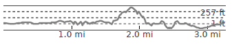
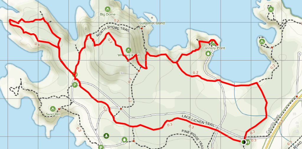
Park outside the Point Lobos State Reserve on Cabrillo Highway and walk to the meeting point near the intersection of the Lace Lichen trail and Carmelo Meadow trail. This is just inside the entrance of the park entrance. We will start of the Lace Lichen trail and hike about a mile to the intersection of the Cypress Grove Trail. Restrooms are located here.
The Cypress Grove Trail loops around the Allen Memorial Grove and offers beautiful vistas of the Cypress Cove, Pinnacle Cove, and South Point. This loop is .8 miles. As you finish the loop, go left at the trailhead for the North Shore Trail. Continue for a short distance until you reach the Whaler's Knoll Trail trailhead. Turn right at the trailhead and go up to the top of the Whaler's Knoll - don't worry it's only 180 feet of elevation gain. From there you will see beautiful vistas of the Carmel Bay.
Continue down the Whaler's Knoll trail and bear left back towards the North Shore Trail.
Follow the North Shore Trail until you reach Whaler's Cove. Whaler's Cove is a great place to rest and take a break. There is also a cultural history museum with docents who will tell you about the whaling that used to occur here. Be on the look out for the giant whale bones in front of the Whaler's Cabin.
When you are done at Whaler's Cove, turn around and head back along the North Shore Trail to the Cabin Trail, making a left. Follow the Cabin trail for about .2 miles and cross over the access road and continue on the trail. The trail changes names to the Granite Point trail. Turn right at the intersection of the Carmelo Meadow Trail and follow it to where we started (.4 miles).
The Forest of the Nisene Marks Monterey Bay Trekkers Hike - Sunday, February 2nd

- Date: February 2nd (Sunday)
- Meet: Do this hike on the way back from the Aquarium - on your own timetable
- Location: The Forest of Nisene Marks, Aptos, CA.
- Hike Distance: 3.5 miles round trip
- Time: Allow 2.5 - 3 hours for the hike
- Parking: $8. No credit cards.
- Park Information
- Directions & All Trails Map
- All Trails App Route Info
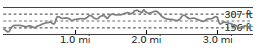
About the park:
Off the beaten path, The Forest of Nisene Marks’ dense second- and third-growth redwood forest rises from near sea level to steep coastal mountains. The park’s land has a bittersweet beauty. Almost all of today’s redwood forest was clear-cut in a 40-year logging frenzy from 1883 to 1923. When the loggers left the Aptos Canyon, the forest began to heal itself; now, the scars grow fainter with each passing year. The Forest of Nisene Marks is a monument to forest regeneration and the future—it is a forest in a perpetual state of becoming.
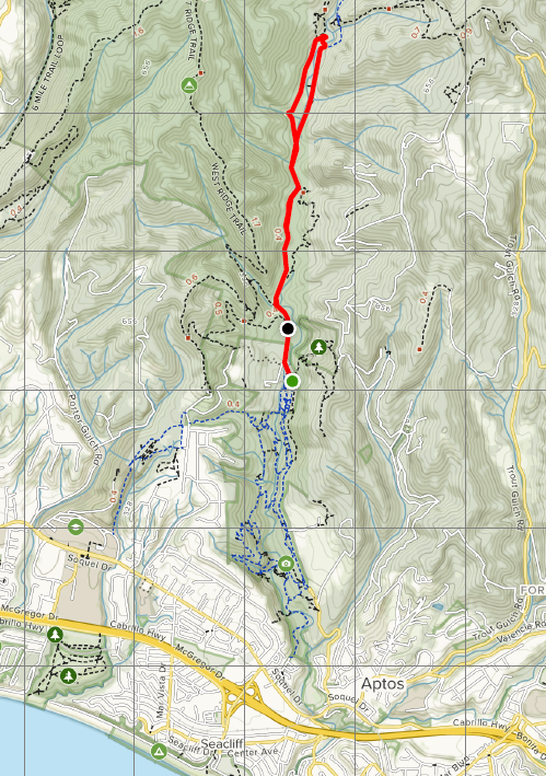
The park's name honors Nisene Marks, the nature-loving mother of the Salinas farm family that bought the land in the 1950s. Her children donated approximately 9,700 acres to the state in 1963 with the provision that the land never be developed. Today, the park showcases a forest in recovery, with rugged canyons and remnants of its once-bustling railroad and logging industry.
Hike Details:
Park at George’s Picnic Area and begin the hike on the dirt road leading through the park, heading north. Immediately as you begin your hike you will cross over the Aptos Creek. Continue north on the dirt road past the Mary Easton Picnic Area and the Porter Family Picnic Area.
As you are hiking, be on the look out for the local inhabitant, the Banana Slug, and a small red and yellow mushroom.
Slightly past the Porter Family Picnic Area you will find a trailhead for the Loma Prieta Grade Trail on your left, follow the Loma Prieta Grade Trail. Hiking along the Loma Prieta Grade Trail you will cross a tributary on a bridge built by the Youth Conservation Corps in the early 1990’s.
As you continue along the Loma Prieta Grade trail be on the lookout for old railroad ties and other historical artifacts left over from the Loma Prieta Logging Company.
Stop and read the interpretive sign detailing the history or the Porter House. At the sign, continue on the trail directly to your right for approximately 20 yards until you see the small ‘Porter House Site’ sign. Look around the site for old bricks and other historical artifacts; however, do not remove anything from its location or from the park!
Continue on the trail that goes down the hill, directly in front of the sign; this is the Mill Pond Trail.
While on the Mill Pond Trail you will cross the Aptos Creek by bridge. When you reach the dirt road, make a right and continue along the road. Not far from here you will find the Loma Prieta Mill Site.
Enjoy the interpretive sign and the old foundation and archaeology of the mill site before you return back to your vehicle.
August Hike: Sycamore Grove Park
Sunday, August 25, 2019
Date/Time: Sunday, August 25, 2019, 9 am-11 am
Location: Sycamore Grove Park (map), Livermore
Meeting Point: Wetmore Road Entrance Parking lot
Attire: Class B (dress in layers)
Awards: Trail Trekkers Cub Scout Patch/Progressive Hike Award
Parking Fee: $7 per vehicle
Hike Info: Hike info
RSVP: Evite
Contact: Hiking Chair Deva Sundararajan
What to bring:
- binoculars, camera
- layers of clothing appropriate for the weather
- Plenty of water and snacks
Our first 2019-2020 hike will be any easy one at the Sycamore Grove Park. The trail is 4 miles long with hardly any elevation gain. Lion and Tiger scouts are encouraged to participate. This park has a lot of reptiles and if we are lucky and patient we can see some. Near the wet area, we can see some great blue herons - don't forget to look up. Wandering among the Park's sycamores, you may be fortunate enough to see a fox, a bobcat, or perhaps a Red-tailed Hawk soaring overhead. Magpies and Bushtits chatter as you stroll along quiet trails. A quiet hiker can sometimes find deer, rabbits and hares, ground squirrels, mice, lizards, snakes, turtles, frogs, and a variety of birds and insects in the park.
September Hike: Mt. Diablo State Park
Sunday, September 29, 2019
Date: Sunday, September 29, 2019
Time: 10:00 am
Location: Mt. Diablo State Park
Trailhead: Curry Point, South Gate Road
Attire: Class B
Awards: Highlander Patch Rocker
Entrance Fee: $10 per car
RSVP: Evite
Contact: Hiking Chair Deva Sundararajan
Information: Flyer
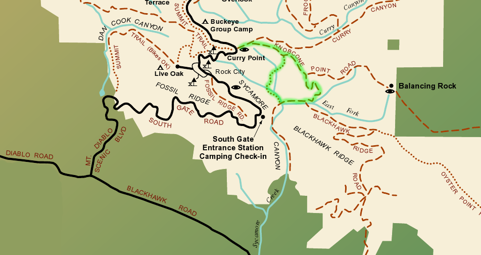
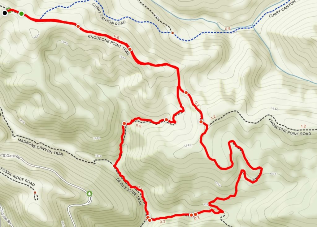
Details: It is an easy 3.3 loop trail with an elevation gain of 700 feet (approx. 1.5 hours). Take the Knobcone Point Road from the parking lot for about 1 mile to Black Hawk Trail. Turn right and continue to Sycamore Creek Road. Turn right again to Devils Slide Trail and turn right. Begin climb out of Sycamore Canyon on this wonderful singletrack trail as it heads back to Knobcone Point Road, where you turn left back to the trailhead. See highlighted trail in map.

What to bring:
- Binoculars, camera
- Layers of clothing – please check weather forecast prior to hike
- Lunch/Snacks/Water
Getting there:
From Crow Canyon Rd continue onto Blackhawk Road. It becomes Diablo Road. Go to Mt. Diablo Scenic Boulevard and turn right. At the Park boundary the road becomes South Gate Road. Continue up the mountain, past the entrance station to just past Rock City. Park in the Curry Point view area on the left.
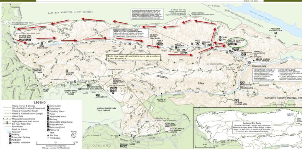
November Hike: Redwood Creek Regional Park
Sunday, November 17, 2019
Date: Sunday, November 17, 2019
Time: 11:00 am
Location: Redwood Creek, East Ridge and Stream Trails, Redwood Regional Park, Oakland
Meeting Point: Canyon Meadow Staging Area
Distance: 6 miles (2 hours)
Attire: Class B
Awards: Trail Trekkers Cub Scout Patch/Progressive Hike Award
RSVP: Here
Parking Fee: $5
Information: Flyer
Contact: Hiking Chair
What to bring:
- Binoculars, camera
- Layers of clothing – please check weather forecast prior to hike
- Lunch/Snacks/Water
Details: This hike will take place in the beautiful Redwood Regional Park in Oakland. This will be a six mile hike (approx. 2 hours with 950 feet in elevation gain) that will reward its hikers with great views of the San Leandro Reservoir and the surrounding hills.
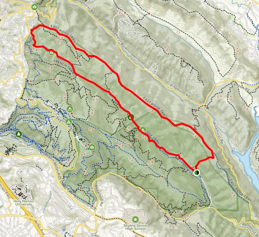

Due to the distance of the hike we recommend all hikers come prepared with plenty of snacks, water and a lunch to enjoy during our break. We will meet at the Canyon Meadow Staging Area and head to the Canyon View Trail. We will then go along the East Ridge until we reach the Skyline Gate. At this time we will have a break and can refill our water bottles or use the restrooms. We will head down the Stream Trail to Mill Site or Fern Hut where we can stop for lunch. If we are lucky the stream will be full and get to see a few of the cascades. We are also hoping to see a special treat: ladybug hibernation. Thousands of ladybugs have been converging in clusters along the Stream Trail between Prince Road and Tres Sendes. Another gathering can be found midway on the French Trail between Tres Sendes and West Ridge Trail (Mother Nature willing, of course).

January Hike: Rodeo Lagoon, Marin Headlands (GGNRA)

Date: On your own
Time: With your family or den
Location: Rodeo Lagoon, Sausalito
Meeting Point: Marin Headlands Visitor Center
Attire: Class B
Awards: Trail Trekkers Cub Scout Patch/Progressive Hike Award. Scouts can also choose to become Junior Rangers.
Fees: None (bridge toll only)
RSVP:
Contact: Hiking Chair Deva Sundararajan
What to bring:
- binoculars, camera
- layers of clothing – please check weather forecast prior to hike
- Lunch/Snacks/Water – Please note that there are NO food vendors in the Marin Headlands
Details
You can begin at the Marin Headlands Visitor Center. Scouts who choose to becoming junior rangers can get Junior Ranger booklets from the Visitor Center (if it is open).
The start of the Rodeo Lagoon Trail Loop is at the picnic area. First cross the footbridge, heading north towards Bunker Road. Go left towards the ocean, following the path around the lagoon. Return to Rodeo Lagoon Loop and continue to follow the path back to the picnic area
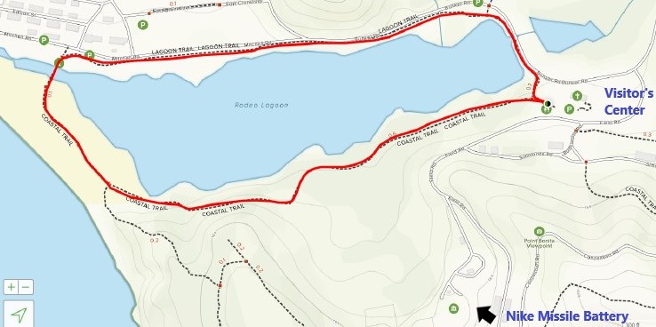
Following the hike, if it is open, you can drive up to the Nike Missile Site site to learn about some of our country's history. This is usually open Saturdays from 12:30 - 3:30 PM, but has been listed as closed in the past months due to COVID. Double check the GGNRA website beforehand.

If it is open, families may also chose to visit the Marine Mammal Center on their own. This too has been listed as closed in the past months due to COVID. Double check their website beforehand.
Don't forget to bring a lunch, snacks and plenty of water. There are no food vendors at this location. Wear appropriate clothes since the weather may change rapidly.
January Hike: Briones Regional Park
January 26, 2020
Date: Sunday, January 26, 2020
Time: 2 pm
Location: Briones Regional Park
Attire: Class B
Award: Highlander Briones rocker patch
Fees: $3 per vehicle (when kiosk is attended)
Meeting Point: Bear Creek Staging Area
Contact: Hiking Chair Sundararajan
RSVP: Evite.
Distance: 2.2 Miles Elevation: 613 feet Download Map.
How to get there
Bear Creek Staging Area: From Highway 24, take the Happy Valley Road exit and go north. Turn right at Bear Creek Road, take the 1st right onto Briones Valley Rd (37.925776, -122.162733).
Parking
Make an immediate left after the kiosk and park in the lower lot.
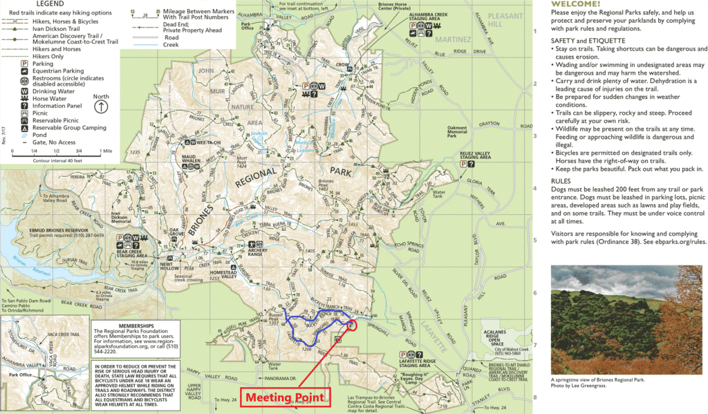
Details:
June 9th: Black Diamond Mines Hike
Date change! Hike is now on June 9th

Date: Sunday, June 9, 2019
Time: 8:30 am
Location: Black Diamond Mines Regional Preserve
Meeting Point: Parking lot ~ a mile beyond the visitor center (37°57'33.9"N, 121°51'46.8"W)
Attire: Class A or B
Awards: Highlander/ TrailTrekker Black Diamond rocker patch
Parking Fee: $5
RSVP: Evite
Distance: 3.5 miles (2-3 hours)
Information: Map & Trail Directions
We will meet at the parking lot that is a approximately a mile beyond the visitor center.
(GPS Coordinates: 37°57'33.9"N, 121°51'46.8"W)
We will hike up the hill to the Rose Hill Cemetery and then backtrack to the Black Diamond Trail to the trails above the mine. The trails will pass by some of the mining features that the Scouts can explore.
This hike does include some steep climbs. Please dress appropriately for the weather and bring plenty of water.
Hiking Patch Program
Unplug! Experience nature and enjoy the Bay Area’s trails.
Pack 1776 will once again be participating in two hiking programs put on by our council, Mt. Diablo Silverado Council (“MDSC”), and the San Francisco Bay Area Council (“SFBAC”). Participation in these hikes go towards hiking patches and requirements for the National Summer Time and Outdoor Activity awards.

MDSC’s program is called the Highlander and includes hikes across Contra Costa County such as Las Trampas (San Ramon), Black Diamond Mines (Antioch), Mt. Diablo (Danville) and Briones (Lafayette).
SFBAC’s hiking program is called Trail Trekkers and encompasses hikes such as Little Yosemite (Sunol), The Hoot Owl, Black Diamond Mines (Antioch), Huckleberry Botanical Preserve (Oakland), Morgan Territory (Livermore), Redwood Creek (Oakland) and so on.
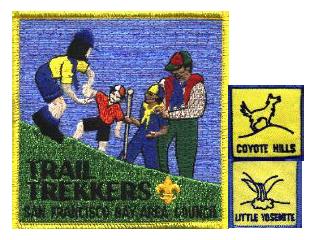
Both programs offer a center patch and smaller ones called “rockers” which surround the center patch and identify which hike a scout has completed. We will be doing a modified version of the programs, mixing in hikes from both patches as we go and awarding the center patch after the completion of three hikes. The center patch will be awarded in a ceremony at the pack meeting following the third eligible hike. Further, while the Pack isn’t working on this program as a group, some of these hikes will be on East Bay Regional Parks land which will qualify you towards their East Bay Regional Parks Trail Challenge.
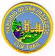
There is also a standalone hiking patch called the Cub Scout Presidio Historical Trail which is for a 3.5-mile trail in San Francisco’s Golden Gate National Recreation Area. We will be doing a modified version of the hike which starts at the Presidio Visitor Center, down to Fort Point, up to the Golden Gate Bridge and throughout the Presidio.
Information about these hikes and the patches can be found in the Hiking Patch section on the Pack Website.
Upcoming Hikes (dates and locations subject to change):
February 10th – Little Yosemite (Trail Trekker Patch Hike)
March 9th - Hoot Owl Hike @ California Nursery Historical Park (Fremont/Niles) (Trail Trekker Patch Hike)
April 7th (NOTE DATE CHANGE) - Huckleberry Botanic Preserve. (Trail Trekker Patch Hike)
May 4th – Bike Hike down the Iron Horse Trail to Hap Magee Park
June 1st - (NOTE DATE CHANGE) Black Diamond Regional Park (Trail Trekker & Highlander Patch Hikes)
July 21st – Cub Scout Presidio Historical Trail in SF. (Cub Scout Presidio Historical Trail patch)
March Hike: Hoot Owl Hike

Date: Saturday, March 9, 2019
Time: 5:45 pm
Location: California Nursery Historic Park, 36501 Niles Blvd., Fremont, CA 94536
Note: This hike is limited to the first 25 scouts and a parent (50 people maximum for this event). Scout only, no siblings. One parent per family. Registration is now closed.
Cost: Free for scouts. $8 per parent. Pay by February 28th to hold your spots. Pay online (fee) or deposit your check in the Scout Box at the Coyote Creek Elementary School by February 28th.
Distance: 1 to 1.5 miles round trip
Time: Allow about 1.5 -2 hours for program and hike.
Suggested Age: Tigers, Wolves, Bears and Webelos.
Attire: Class B uniform
Award: This is a Trail Trekker Patch Hike. Participating scouts will receive a Hoot Owl patch.
Meeting Location: California Nursery Office
Contact: Hiking Chair Deva Sundararajan
Must read: Hike Detail
Come join us for the 2019 Hoot Owl Hike at the California Nursery Historic Park.
The California Nursery Historic Park has many old trees that are ideal for Owls and other Raptors to roost, nest and hunt from in search of food. Bring your flashlight and walk through the grounds at dusk, this is a good time to spot an owl in the trees or hunting for prey. Meet at the California Nursery Office for an introduction to owls and then walk at the sun goes down you will look and listen for the raptors that hunt at night. Discover owl pellets and the bones of what the owls ate at the Vallejo Adobe. Other night birds will also be seen in this forest in a park. Small flashlights are acceptable.
This hike is limited to the first 25 scouts and a parent who has submitted his or her payment by February 28th. Free for scouts. (50 people maximum for this event). SIGN UP HERE TO ATTEND.
Scouts completing this hike will earn the Hoot Owl Trail Trekker rocker patch.


