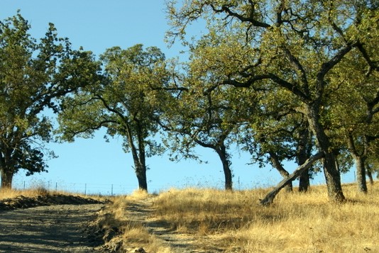
April 7th Hike: Huckleberry Botanical Preserve
DATE CHANGE: Sunday, April 14, 2019. April 7, 2019
Time: 3:00 p.m.
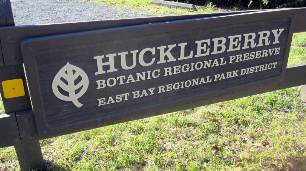
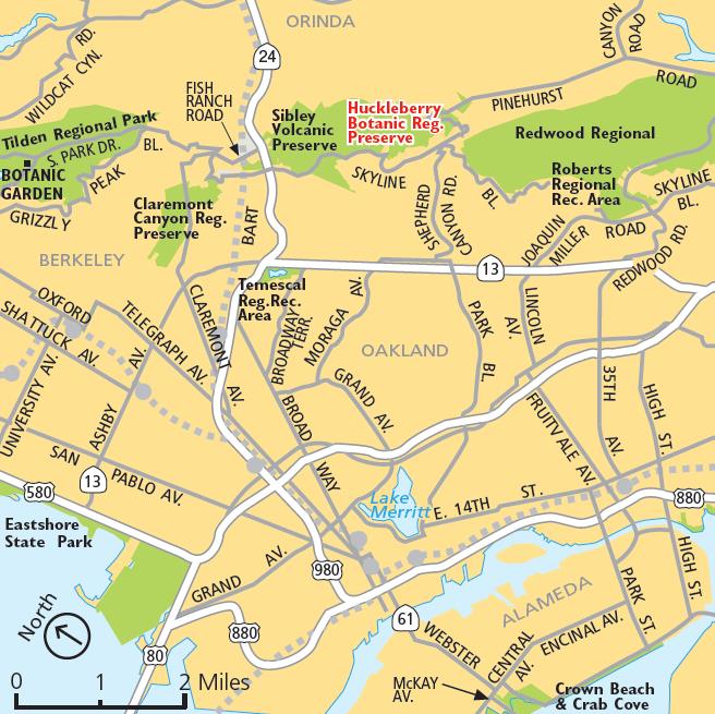
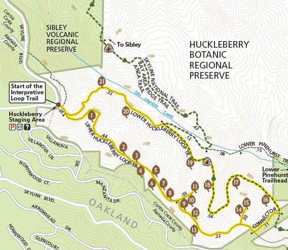
Location: Huckleberry Botanic Preserve, 7087 Skyline Blvd., Oakland, CA 94611
Cost: Free for all.
Distance: 1.7 miles round trip
Time: Allow about 2 hours
Suggested Age: All ages. RSVP HERE
Attire: Class B uniform
Award: This is a Trail Trekker Patch Hike. Participating scouts will receive a Huckleberry Preserve Patch. This hike also qualifies for the EBPRD Trails Challenge.
Contact: Hiking Chair Deva Sundararajan
Directions: From Highway 24 in Oakland, take the Fish Ranch Road exit immediately east of the Caldecott Tunnel. Continue 0.8 miles to Grizzly Peak Blvd. Turn left and go 2.4 miles on Grizzly Peak to Skyline Boulevard. Turn left and drive approximately one half mile to the park entrance on the left, past Sibley Volcanic Regional Preserve. Access: Google Directions.
The object of this hike is to educate our Scouts about the different plants and trees that are found within the preserve, this is why the estimated time is 2 hours for a 1.7 mile hike. The guide book will help in our discussions with the Scouts of the various plants and trees found in the Huckleberry Botanic Regional Preserve. An unabbreviated version is found in the East Bay Trail Map for are provided here in for the scouts to use for identification.
Postponed: Bike Hike!
The May 4th Bike Hike is canceled. Look for a new date in Summer!

Date/Time: Saturday, May 4, 2019, 4:00 pm
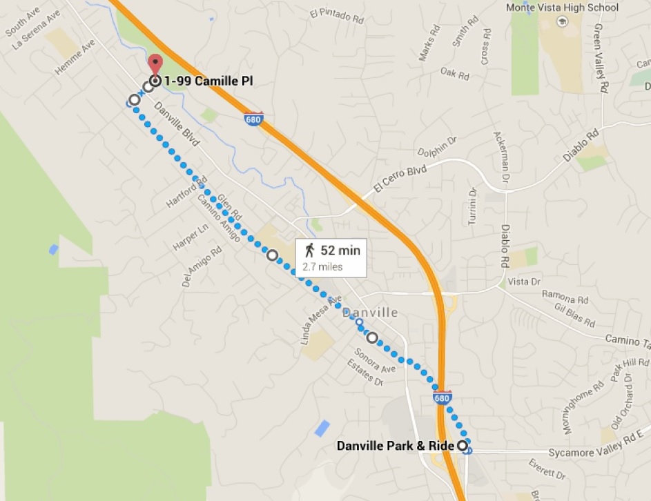
Location:Sycamore Park and Ride to Hap Magee Ranch Park and back.
Distance: 2.8 miles one way - approx. 6 miles total
Time: Allow 60-70 mins
Attire: Class B uniform
Meeting Point:Sycamore Park and Ride Lot
Contact: Hiking Chair Deva Sundararajan
RSVP: here so we can get a headcount
Trail:Take the Iron Horse Trail going north starting at Sycamore Valley road. Head on to Camille Ave and bear right. Cross Danville Blvd to head to Hap Magee Ranch Park. Kids can take a break at the park and have some snacks and water and get ready for the journey back. See map below.
What to Bring:
Bikes! Helmets!
Water and Snacks
Basic first Aid kit (optional)
Parents: We want as many of you bikers as possible! Siblings on bikes welcome. We will have different groups of skilled riders, so you everyone can ride at the pace most comfortable for them. We will go over bike safety rules and do a quick helmet inspection before we start. Absolutely no racing or horseplay permitted.
August Hike – Las Trampas
 Date: Saturday, August 27th, 2016
Time: 4:00 pm
Location: Las Trampas Regional Wilderness
Meeting Point: Parking lot at the end of Bollinger Canyon Road
Attire: Class B or casual clothing
Awards: Highlander patch and/or the Las Trampas Rocker patch
Fees: None
RSVP: Evite
Contact: Hiking Chair - Siddharth Bhatia
Directions
From Highway 680: Take the Crow Canyon Road exit. Drive west on Crow Canyon for about 1 mile, then turn right (north) onto Bollinger Canyon Road. Continue about 4.5 miles to the trailhead at the end of the road. Alternatively, drive west on Bollinger till it ends at the park. About 10 miles from school on Bollinger Canyon Road.
Meet at the parking lot at the end of the road inside the park.
Trail
Bollinger Creek Loop trail. A very nice nearly flat 1.2 Mile trail. Should take less than 1 hr to complete. Easy hike for our younger scouts a nice hike to start off this scouting year. Since this is a short hike we can start later when it is slightly coiler.
What to bring:
- Binoculars, camera
- Plenty of water and snacks

April Hike – Little Yosemite
 Date: Saturday, April 30, 2016
Time: 10:00am
Location: Little Yosemite, Sunol Regional Wilderness, Sunol
Meeting Point: Parking lot near the Old Green Barn Visitor Center
Attire: Class A or B
Awards: Trail Trekkers Cub Scout Patch/Progressive Hike Award
Parking Fee: $5
RSVP: Evite
Contact: Hiking Chair Siddharth Bhatia
Little Yosemite is a scenic gorge with gorgeous waterfalls and pools.
Details
The Canyon View Trail is an excellent hike for Cub Scouts and a great way to get to Little Yosemite. The trail begins near the Visitor Center, at the bridge that crosses the creek. After crossing the bridge, turn right and head upstream. The Canyon View trail is well marked. The trail goes up a ridge (or two) and proceeds along the hillsides that border the creek. Along the way, you'll see some nice views of the creek and canyon. About halfway, the trail drops down into Jacobs valley. Stay on the trail until you get to Cerro Este Road and turn right (toward the creek) and follow the road to Little Yosemite. When you get to the outhouse on Camp Ohlone Road, cross the road where you will find a path that will take you down the very steep sides of the creek's banks, to the ancient piles of boulders called Little Yosemite.
This is a perfect place for boys to study rocks and have lunch. Remember collecting specimens is not allowed. Watch for poison oak.
Hikes can return the same way they came, or via the Ohlone Road for a different view of the park. To return via Ohlone Road simple climb back up the bank to the road (stay on the trail), downhill. Notice how different the vegetation is here by Alameda Creek, compared to the Canyon View Trail. Eventually you will cross a bridge, pass a gate and find yourself in a remote parking area. Stay on the paved road all the way back to the Visitor Center.)
Getting there:
Go south on I-680 and exit at Calaveras Road/Highway 84 just south of the town of Pleasanton. Turn left onto Calaveras Road and proceed to Geary Road, which leads directly into the park.
January Hike – Bishop Ranch Regional preserve
 Date/Time: Sunday Jan 31, 2016, 2-4pm
Location: Bishop Ranch Regional Preserve
Meeting Point: Trail entrance at Morgan drive
GPS coordinates: 37°44'58.4"N 121°57'47.0"W
Parking & Fees: Park on Morgan drive. No paid parking available.
Attire: Class A or B uniform (dress in layers)
Award: Opportunity to enjoy our neighborhood open green space
RSVP: Evite
Contact: Hiking Chair Siddharth Bhatia 408.431.8037
What to Bring:
Plenty of water and snacks
layers of clothing appropriate for the weather
binoculars, camera (optional)
In January, let's explore areas in our community where we can go for a short hike. The Bishop Ranch Regional Open Space Preserve offers quiet and solitude on 444 acres just a short distance from San Ramon Valley subdivisions. Watch for animals such as deer, red-tailed hawks, and turkey vultures.
The trail will be a short 2.5 mile loop comparable to our last two hikes so it should take about 90 mins to complete. Elevation gain will be about 400 feet which is similar to the 350 feet we had at our last hike in Coyote hills regional park.
December Hike – Coyote Hills
 Date/Time: Saturday, December 12, 2015, 10am-12pm
Location: Coyote Hills Regional Park, Fremont
Meeting Point: Visitor Center Parking Lot
Parking & Fees: Parking at the Visitor Center. $5 parking fee.
Attire: Class A or B uniform (dress in layers)
Award: Trail Trekkers patch
Hike Info: SFBAC file
RSVP: Evite
Contact: Hiking Chair Siddharth Bhatia
What to Bring:
Plenty of water, snacks. Wear clothes appropriate for the weather.
- binoculars, camera (optional)
- layers of clothing appropriate for the weather
- Plenty of water and snacks
- Sack Lunch (optional) Scouts can have lunch after the hike.
The hike at Sycamore Grove park was a nice and easy one so let's do something more exciting in December. After all, we need to burn all the calories from all the yummy food we eat during the holidays.
Our next hike in December will be an moderate hike at Coyote Hills Regional park in Fremont. The trail is about 4 miles long with few short hills. Tiger scouts are encouraged to participate. The kids will enjoy walking on the boardwalk and we will stop at the wildlife viewing platforms to observe water fowl and possibly muskrats. We might see some herons and cranes that visit the bay this time of the year as they head south for the winter. On a clear day the views are great.
Coyote Hills is an important wildlife sanctuary. Its marshes are part of the Pacific Flyway, an aerial highway for migrating waterfowl and other birds. Deer are frequently seen here, as well as raccoons, foxes, muskrats, and skunks. We will look for their tracks in muddy areas.
November Hike – Sycamore Grove
 Date/Time: Sunday, Nov 22, 2015, 10am-12pm
Location: Sycamore Grove Park (map), Livermore
Meeting Point: Wetmore Road Entrance Parking lot
Attire: Class A or B (dress in layers)
Awards: Trail Trekkers Cub Scout Patch/Progressive Hike Award
Parking Fee: $5 per vehicle
Hike Info: Hike info
RSVP: Evite
Contact: Hiking Chair Siddharth Bhatia
What to bring:
- binoculars, camera
- layers of clothing appropriate for the weather
- Plenty of water and snacks
The hike at Redwood Park was a great start to our hiking calendar - it was 2.6 miles long with an elevation gain of 1200 feet - quite an achievement for our scouts !
Our next hike in November will be any easy one at the Sycamore Grove Park. The trail is 2.5 miles long with hardly any elevation gain. It will feel like a walk in the park after our Redwood Park hike. Tiger scouts are encouraged to participate. This park has a lot of reptiles and if we are lucky and patient we can see some. Near the wet area, we can see some great blue herons - don't forget to look up. Wandering among the Park's sycamores, you may be fortunate enough to see a fox, a bobcat, or perhaps a Red-tailed Hawk soaring overhead. Magpies and Bushtits chatter as you stroll along quiet trails. A quiet hiker can sometimes find deer, rabbits and hares, ground squirrels, mice, lizards, snakes, turtles, frogs, and a variety of birds and insects in the park.
June Hike – “Clean Up Hike”

Location: Around Coyote Creek
Time: Allow 1 hour
Attire: Class A uniform
Award: "Every day is Earth day" patch
Meeting Point: Coyote Creek Elementary MPR
Contact: Hiking Chair Siddharth Bhatia
RSVP: Evite
What to Bring:
Your trash hunting skills
Good attitude
Details:
Let's end this school year by cleaning up our beloved school and surrounding areas. Scouts will walk along the school perimeter picking up trash. We will hand out gloves and garbage bags. We will also talk about recycling and discuss
which items can be recycled. Scouts will be doing their part in keeping our school clean and following the principles of Leave No Trace.
Route:
Walk along the outer perimeter of the school and then walk around Briza Loop. We can split into groups and explore areas around Lantana Way/Cattleya Drive if time permits.
January Hike – Las Trampas Regional Wilderness
Date: Saturday, January 10, 2015
Time: 11:00 am
Location: Las Trampas Regional Wilderness
Meeting Point: Parking lot at the end of Bollinger Canyon Road
Attire: Class B
Awards: Highlander patch and/or the Las Trampas Rocker patch
Fees: None
RSVP: Evite
Contact: Hiking Chair - Siddharth Bhatia
Directions
From Highway 680: Take the Crow Canyon Road exit. Drive west on Crow Canyon for about 1 mile, then turn right (north) onto Bollinger Canyon Road. Continue about 4.5 miles to the trailhead at the end of the road. Alternatively, drive west on Bollinger till it ends at the park. About 10 miles from school on Bollinger Canyon Road.
Meet at the parking lot at the end of the road inside the park.
Trail
Bollinger Creek Loop trail. A very nice nearly flat 1.2 Mile trail. Should take less than 1 hr to complete. Easy hike for our younger scouts a nice hike to start off the new year in scouting. Since this is a short hike we can start later when it is slightly warmer.
What to bring:
- Binoculars, camera
- layers of clothing – this hike can be cold and windy
- Plenty of water and snacks
Overview
Las Trampas (Spanish for the traps) has two distinct areas, each with its own personality. Rocky Ridge, on the west side of the valley, is known for views in all directions, unusual rocks and green rolling hills lightly forested with California bays, oaks and maples. The wildflower display on the hills just off the ridgeline is an east bay favorite. The Las Trampas Ridge, to the east, is quite different, featuring a plant community dominated by chamise with other chaparral plants such as manzanitas and coyote brush.
Cancellation Policy
Cancelled if rain is forecast for the day of the hike. Look for an email from Sid on Friday evening before the hike.
December Hike – Sycamore Grove
Date: Saturday, Dec 13, 2014
Time: 9 am
Location: Sycamore Grove Park (map), Livermore
Meeting Point: Wetmore Road Entrance Parking lot
Attire: Class A or B (dress in layers)
Awards: Trail Trekkers Cub Scout Patch/Progressive Hike Award
Parking Fee: $5 per vehicle
Hike Info: Hike info
RSVP: Evite
Contact: Hiking Chair Teresa Noble
What to bring:
- binoculars, camera
- layers of clothing – this hike can be cold and windy
- Plenty of water and snacks
Details
Every inch of this park is alive with life - in the air, in the grass, even in puddles. Begin your search for signs of wildlife at the Wetmore Road entrance. Follow the paved path until you come to the first sign designating the Nature Area. Turn left onto the broad trail that crosses the usually dry Arroyo. Follow this nature trail through the sycamore grove until you reach the park boundary. While you are here, be sure to pause often and listen for the sounds of reptiles and rodents in the grass. If you are lucky and very patient you might even see an animal. Near the wet areas be sure to look for great blue herons. Don't forget to look up!
About The Park
The park is home to a variety of wildlife. Along the Arroyo Del Valle you might see frogs, pond turtles, dragonflies, ducks or even muskrats. In addition to this riparian area there are grassland and oak woodland habitats. Deer, ground squirrels, butterflies, lizards and birds such as red-tail hawks, white-tail kites, scrub jays, magpies and meadowlarks are just few of the animals you might spot in these areas.


