October Hike and Enrichment Programs
Date: Sunday, Oct 28, 2012
Time: 10:30 am (please see other meeting times/locations below).
Location: Multiple locations in Golden Gate National Recreation Area, Marin and vicinity
Attire: Class B
Awards: Wildlife conservation belt loop, Trail Trekkers Cub Scout Patch/Progressive Hike Award. Scouts can also choose to become Junior Rangers.
Fees: None (only bridge tolls)
Sign up: Evite (Check your spam/junk mail folder if you haven't received it)
Must read: Hike info
Important Notes: Rain/Heavy Fog cancels the event. Parking can be an issue on Hawk hill so arrival by 11.30 am is recommended to avoid the walk uphill.
Contact: Hiking Chair Sachin Sheth

Destinations
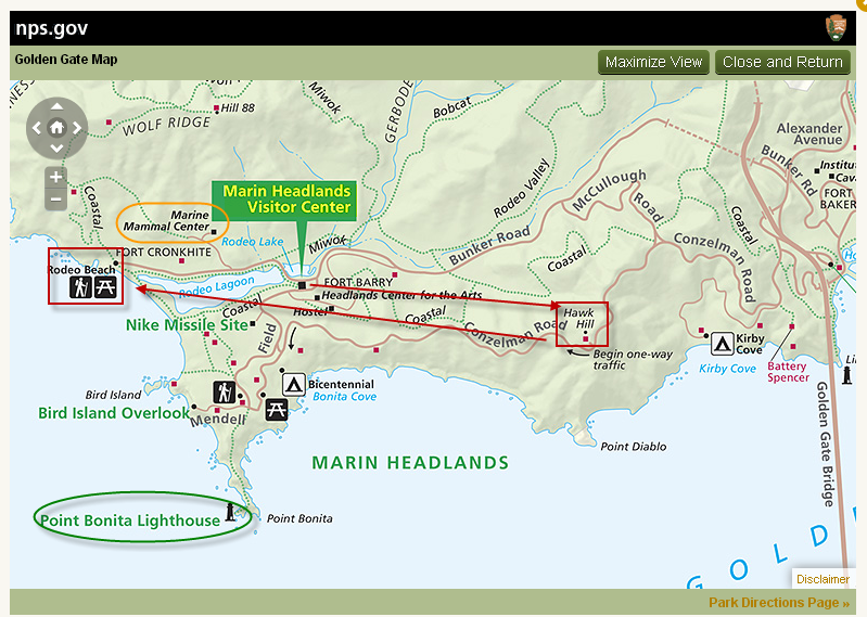
(1) Marin Headlands Visitor Center (2) Hawk Hill (3) Rodeo Lagoon
Meeting Point (s)
Marin Headlands Visitor Center (10.30 AM)
Hawk Hill (11.30 AM)
Rodeo Beach Picnic Area (2.30 PM)
Details
At the Marin headlands visitor center we will review the exhibits and get a Junior Ranger booklet for the kids. The visitor center opens by 9.30 AM, so feel free to arrive early. At 11.15 AM we will head out to Hawk hill for the hawk talk. After the talk ~1.15 PM participants can head to the picnic area on Rodeo Beach by the trail head or choose to get a bite to eat in Sausalito. Hike will begin at 2.30 PM.
Marin Headlands Visitor Center
The Center's exhibits introduce the Headland's natural history and trace the area's human history from the days of the Miwoks through modern times. You can see how a hawk flies and look through a microscope at the hidden life of local ponds. A Miwok shelter invites you inside to listen as present-day Coast Miwok people talk about their lives. A shop carries a good selection of books and field guides about the area. You can choose to become a Junior Ranger.
Halk Talk
The Hawk Talk and Banding Demonstration begins at noon - a GGRO volunteer speaks about hawk migration and identification, and what they do at the GGRO. Then at 1pm, a banding volunteer brings up a newly banded hawk, talks about the banding program, shows everyone the hawk, and lets it go in front of the crowd. It is a great way to learn about hawks and see one up close.
Rodeo Lagoon Hike
This is an excellent hike for those just beginning to take nature hikes with scouts. Rodeo Lagoon in the Golden Gate National Recreation Area is a natural lagoon formed by beach buildup. It generally catches fresh water that flows down the valley from ridges above, but waves occasionally wash over the beach during winter storms, forming brackish water.
Distance, category, and difficulty:
Easy, 1.5 miles
Hiking time:
< 1 hour. The kids can play on the beach after.
Exposure:
Exposed
Trail surfaces:
Dirt fire roads and trails
What to bring:
- Binoculars
- Long pants
- Dress in layers/Jacket – Please check weather forecast prior to hike.
- Lunch/Snacks – Please note that there are NO food vendors in the marin headlands
- Water
If it is not very cold, you may choose to wear sandals instead of shoes.
Getting there:
- Cross the Golden Gate Bridge and take the second exit Alexander Avenue.
- To Marin Headlands Visitor Center - Stay to the right on the exit ramp to get onto Alexander Ave. Turn left on Bunker Road (a brown sign saying "Marin Headlands Visitor Center" marks the intersection). Go through the one-way tunnel and drive approximately 2 miles. Turn left onto Field Road. The visitor center will be on the right side of the road.
- To Hawk Hill - Get in the left lane following signs that read "101 San Francisco." Turn left at the stop sign and cross under the freeway. Turn right onto Conzelman Road and drive 1.8 miles to Hawk Hill. Park alongside the road at the top of the hill, just before the road becomes one way. Walk up the west side of Hawk Hill past the locked gate. It's just a few hundred feet to the summit.
- To Rodeo Lagoon - After about 0.3 mile, turn left onto Bunker Road. There is a one-way tunnel which cuts under 101, and you may need to wait up to 5 minutes for your turn to travel through it (this is a great opportunity to put on sunscreen). From the other side of the tunnel, drive about 3 miles on Bunker Drive to the trailhead at the end of the road.
Get driving or public transit directions from Transit and Trails:
http://www.transitandtrails.org/trailheads/301
GPS coordinates* for trailhead:
Latitude 37°49'56.31"N
Longitude 122°32'19.83"W


