October 16: Coyote Hills Trail Trekkers hike
Date/Time: Sunday, October 16, 2022, at 9:30am
Location: Coyote Hills Regional Park — 8000 Patterson Ranch Road, Fremont, CA 94555
Meeting Point: Outside Visitor Center
Fee: $5 per vehicle, $2 per dog
Distance / duration: 4 miles / 3 hours
Difficulty: Easy to moderate — a few short but steep hills
Recommended for: Tigers through Webelos
Hike Info: Hike info / Trail map below
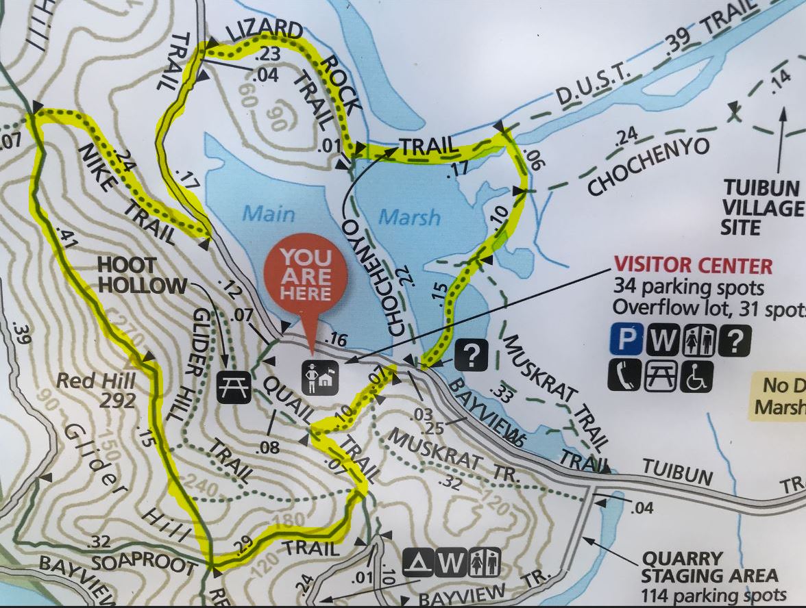
Park map: map
Awards: Trail Trekkers Cub Scout Patch
Contact: Hiking Chair Zhen Zhou (925-997-4889)
[ RSVP ]
Attire:
- Class B and dress in layers
- Sturdy closed toe shoes
What to bring:
- Sunscreen, cap
- Plenty of water and snacks
Directions
Coyote Hills is at the west end of Patterson Ranch Road/ Commerce Drive in Fremont. From I- 880, take Highway 84 west, exit at Paseo Padre Parkway and drive north. Turn left on Patterson Ranch Road (parking fee).
The hike
This hike will introduce the pack to the marsh and hills of Coyote Hills Regional Park and give you a chance to see a great Visitor Center. It is about 4 miles long, with a few short but steep hills.
The trail
First Head into the marsh by crossing the park road at the south end of the Visitor Center parking lot. The kids will enjoy walking on the boardwalk. Stop at the wildlife viewing platforms to observe water fowl and possibly muskrats.
When the boardwalk ends, keep heading straight, gradually curving to the left, until you reach the D.U.S.T. Trail. Turn left on this trail, then right on Lizard Rock Trail. You will then join Bayview Trail, a paved bicycling trail which encircles the hills. Turn left on the Bayview Trail. When you reach Nike Trail, follow it up to a saddle. Once on the saddle, head south on the Hill Trail. After a short steep climb, you'll reach Red Hill Top, a hill formed of red chert. Watch out for poison oak among the rocks.
On a clear day, the views are great. You'll want to point out some of the sights - the salt evaporation ponds to the west, the marsh and boardwalk below you to the east (can you see where you were?), and some of the high peaks in the Bay Area. Some of these peaks are "Rim Rover" peaks which the boys can climb when they become Boy Scouts - Mission Peak just a little southeast, Mt. Tamalpais to the northwest (beyond San Francisco), and Mt. Diablo to the northeast.
Continue south, stopping at Glider Hill to watch people flying model gliders. Go slowly down the steep hill to Soaproot Trail and go left, passing above Dairy Glen, the group campsite. Turn left again, back to the Visitor Center (you'll be approaching the Visitor Center from behind.)
Alternate Routes
Longer or shorter loops can easily be made - consult the park map. The minimum requirement for this patch is to hike to Red Hill Top.
Visitor Center post-hike
Consider visiting the Visitor Center after the hike. Coyote Hills Visitor Center contains educational displays and exhibits as well as the Possum's Pocket Nature Store. The exhibits portray the Ohlone way of life and include a tule reed boat constructed by park staff and volunteers using Native American methods. Other exhibits cover the park's natural history and wildlife. Open 10am - 4pm on Sundays.
For all in-person pack or den events and activities, please adhere to the pack's COVID statement. If you are sick, are experiencing symptoms, or may have been exposed to COVID-19, please stay home and stay safe.


