Sep 10: Pack Hike – Black Diamond
Date: Sunday, 10 Sep
Time: 9:30 AM PT - 12:00 PM PT
[ RSVP ]
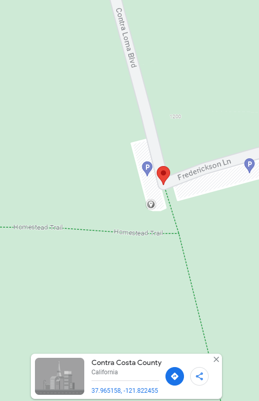
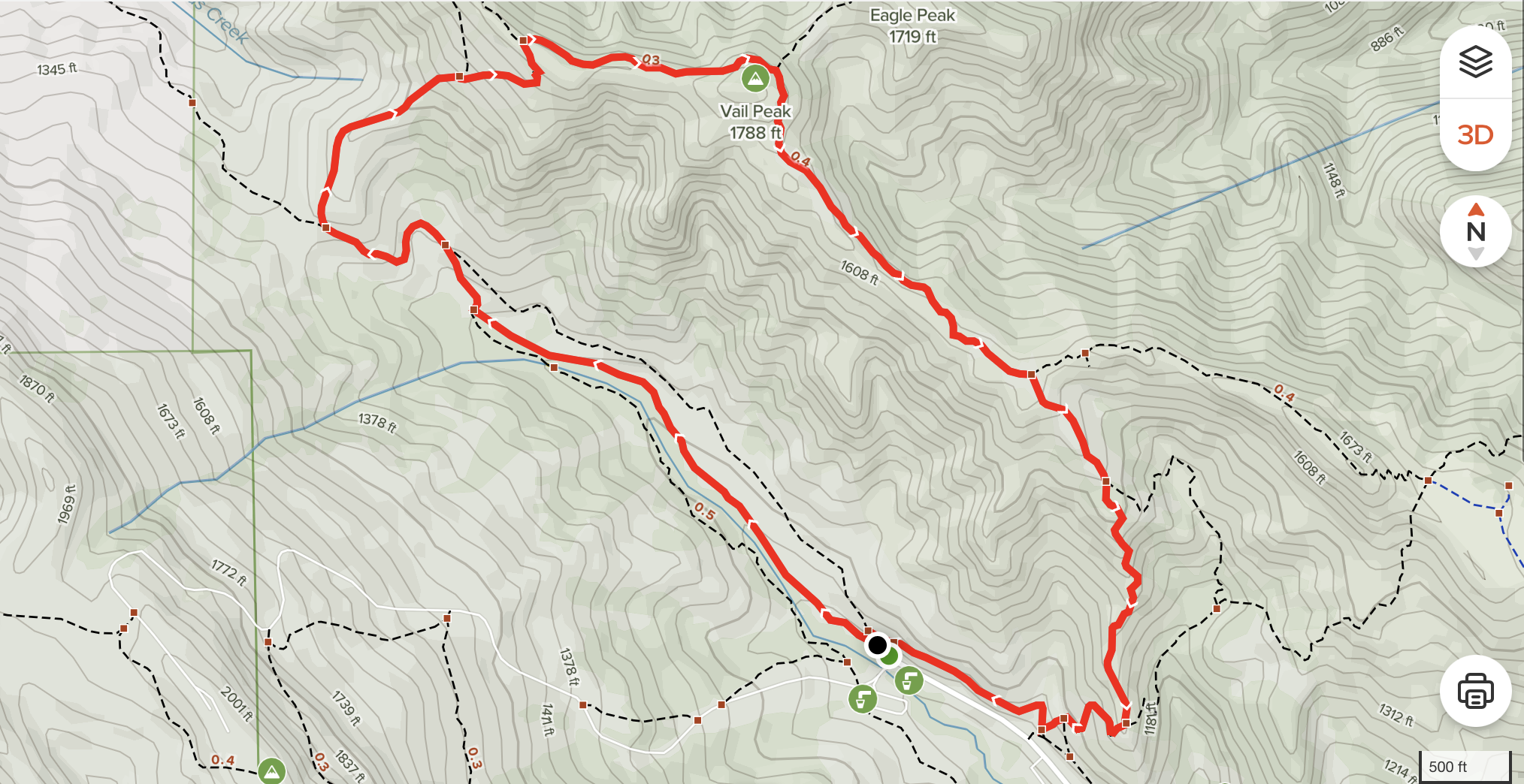
Location: Black Diamond Mines Regional Preserve (Frederickson Lane and Contra Loma Blvd, Antioch, CA) // Stewartville, Contra Loma, North Portal, and Old Homestead Loop Trail
Meeting Point: Stewartville Trailhead — south west corner of parking lot at cross streets Frederickson Lane and Contra Loma Blvd, Antioch, CA
Distance / elevation / duration: 3.3-mile loop / 561 ft / 1 hour 32 mins average
Difficulty: Easy to moderate, with elevation Recommended for: All, with close parental supervision for younger ones
Hike info + trail map: https://www.alltrails.com/explore/trail/us/california/stewartville-contra-loma-north-portal-and-old-homestead-loop-trail?mobileMap=false&ref=sidebar-static-map
Awards: Trail Trekkers program / Highlander program progressive patch / Black Diamond rocker patches —https://ggacbsa.org/hiking-programs/
Attire: Class B t-shirt and comfortable pants, layers, hiking boots/shoes
Bring: Sunscreen, cap/wide brimmed hat, plenty of water and snacks, optional hiking poles, camera
Hike Chair: Zhen Zhou (925-997-4889)
The hike - Discover this 3.3-mile loop trail near Antioch, California. Generally considered an easy route, it takes an average of 1 h 32 min to complete. This is a very popular area for birding, hiking, and running, so you'll likely encounter other people while exploring. The trail is open year-round and is beautiful to visit anytime.
Directions:
https://goo.gl/maps/gCL2jaebvW1PBehNA
Take I-680 N. Keep right to continue on CA-242 N for 3.2 miles. Use left lanes to merge onto CA-4 E (13.2 miles). Take exit 28 / Lone Tree Way / A street in Antioch from CA-4 E. Turn right onto Lone Tree Way (1.5 miles), right onto Gold Course Rd (0.7 miles), then right onto Frederickson Lane (1 mile — partial restricted usage road). Frederickson Lane becomes Contra Loma Blvd (restricted usage road). Parking lot is at the corner on left.
For all in-person pack or den events and activities, please follow the SRVUSD COVID guidelines. If you are sick or are experiencing symptoms, please stay home and stay safe.
Aug 13: August Pack Hike!
Date/Time: Sunday, August 13, 2023, at 9am
Location: Little Yosemite — Sunol Regional Wilderness
Meeting Point: Parking lot immediately to the left after the entrance kiosk - 1895 Geary Road, Sunol, CA 94586
https://www.ebparks.org/parks/sunol
[ RSVP ]
Fee: $5 parking fee / $2 per dog
Distance / elevation: 4.8-mile loop / 524 ft
Difficulty: Easy to Moderate / Recommended for Tigers to Webelos
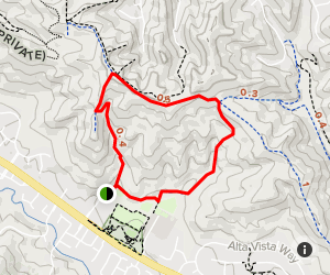
Trail map: https://b846b6.p3cdn1.secureserver.net/wp-content/uploads/2019/12/little-yosemite-map.jpg
Awards: Trail Trekkers Cub Scout Patch // Progressive Hike Award https://ggacbsa.org/hiking-programs/
Contact: Hiking Co-Chair Murali Kattimani / 408-250-0542
What to wear - Class B and dress in layers, incl. windbreaker - Approved face covering - Sturdy closed toe shoes - Hat + sunscreen
What to bring - binoculars, camera - plenty of water and snacks - map
Directions
Drive south on I-680 and exit at Calaveras Road/Highway 84, just south of Pleasanton. Turn left onto Calaveras Road and proceed to Geary Road, which leads directly into the park.
Important
Trails can be quite steep
Watch for poison oak on narrow sections of trail
Rattlesnakes may be in rocky areas — careful where you place hands and feet
No swimming allowed in Alameda Creek in the Little Yosemite area
There will be cattle at Sunol -- give them plenty of distance
The hike
Little Yosemite is located in Sunol Regional Wilderness Park in Sunol, CA. Little Yosemite is a scenic gorge on Alameda Creek about two miles upstream from park headquarters. It is an especially attractive portion of this creek. See gorgeous waterfalls and pools after series of rain storms or season.
The trail
The Canyon View Trail is an excellent hike for Cub Scouts and a great way to get to Little Yosemite. The trail begins near the Visitor Center, at the bridge that crosses the creek. After crossing the bridge, turn right and head upstream. The Canyon View trail is well marked. The trail goes up a ridge or two, and along the hillsides that border the creek. Along the way, you'll see some nice views of the creek and canyon. About halfway, the trail drops down into Jacobs’s Valley. Stay on the trail until you get to Cerro Este Road and turn right (toward the creek) and follow the road to Little Yosemite. When you get to the outhouse on Camp Ohlone Road, cross the road where you will find a path that will take you down the very steep sides of the creek's banks, to the ancient piles of boulders called Little Yosemite. This is a perfect place for scouts to study rocks and have lunch. Remember collecting specimens is not allowed. Watch for poison oak. Hikers can return the same way, or via the Ohlone Road for a different view of the park. To return via Ohlone Road, simply climb back up the bank to the road (stay on the trail), downhill. Notice how different the vegetation is here by Alameda Creek, compared to the Canyon View Trail. Eventually you will cross a bridge, pass a gate and find yourself in a remote parking area. Stay on the paved road all the way back to the Visitor Center.
The history
The original inhabitants in the Sunol Valley were the Ohlone Indians and reminders of them can be seen in the acorn pounding bedrock mortars found in the park. For the past half century, the land known today as Sunol Regional Wilderness was used almost exclusively as ranch land. Alameda Creek is the county's largest stream and hosts an attractive community of trees including alder, willow, sycamore and bay laurel. The nearby valleys abound with coastal live oak, blue and valley oak, elderberry, madrone, and California buckeye. During spring, the hills come alive with a variety of colorful wildflowers. A wildflower identification kit may be checked out at the visitor center.
For all in-person pack or den events and activities, please follow the SRVUSD COVID guidelines. If you or your Scout are sick, are experiencing COVID-like or flu symptoms, or may have been exposed to COVID-19, please stay home and stay safe.
June 25: Hike Martin Canyon Creek Trail
Date/Time: Sunday, June 25, 2023, at 10am
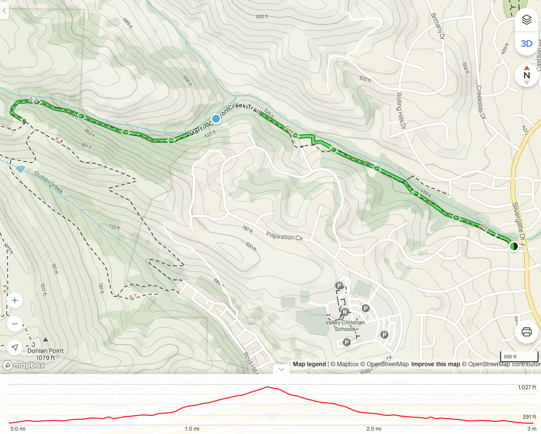
Location: Martin Canyon Creek Trail — 11574 Bay Laurel Street, Dublin, CA 94568
Meeting Point: Trailhead — on Bay Laurel St
Distance / elevation / duration: 2.9-mile out and back / 554 ft / 1 hour 24 mins average
Difficulty: Easy to moderate, with elevation
Recommended for: All, with close parental supervision for younger ones
Hike info: Hike info + Trail map
Directions: Google maps
Awards: Pack hike patch
[ RSVP ]
Attire: Class B t-shirt and comfortable pants, layers, hiking boots/shoes
Bring: Sunscreen, cap/wide brimmed hat, plenty of water and snacks, optional hiking poles, camera
Hike Chair: Zhen Zhou (925-997-4889)
Directions
Take exit 31 toward San Ramon Valley Blvd from I-680 S. Turn left on San Ramon Valley Blvd, then continue on San Ramon Rd, and then right onto Silvergate Rd. https://goo.gl/maps/rjFy8jmtUNGZDDXA6
Plan to arrive early as parking may be limited in this residential area. Please be respectful of residents.
The hike
Enplore this 2.9-mile out-and-back trail near Dublin, California. Generally considered a moderately challenging route, it takes an average of 1 h 24 min to complete. Majority is shaded. This is a very popular area for birding, hiking, and running, so you'll likely encounter other people and possibly wild animals (coyote has been spotted previously) while exploring. Watch out for poison oak.
The trail is open year-round and is beautiful to visit anytime. Dogs are welcome, but must be on a leash.
The trail
The Martin Canyon Creek Trail is one of Dublin's little known treasures. This improved trail follows Martin. Canyon Creek for 0.89 miles and offers amazing views of the Tri-Valley and the canyons leading to the west. Large oaks and bay trees line the creek and trail and provide tranquil areas for respite. The trailhead is located near the corner of Silvergate Dr and Bay Laurel St. Second part is narrow and steep — careful with young ones.
For all in-person pack or den events and activities, please follow the SRVUSD COVID guidelines. If you are sick or are experiencing symptoms, please stay home and stay safe.
April 16: Pack Hike – Briones Park
Location: Briones park, Alhambra Creek Trai
Attire: Class B
Date: Sunday, April 16, 2023
Time: 10:00 AM PT - 12:00 PM PT
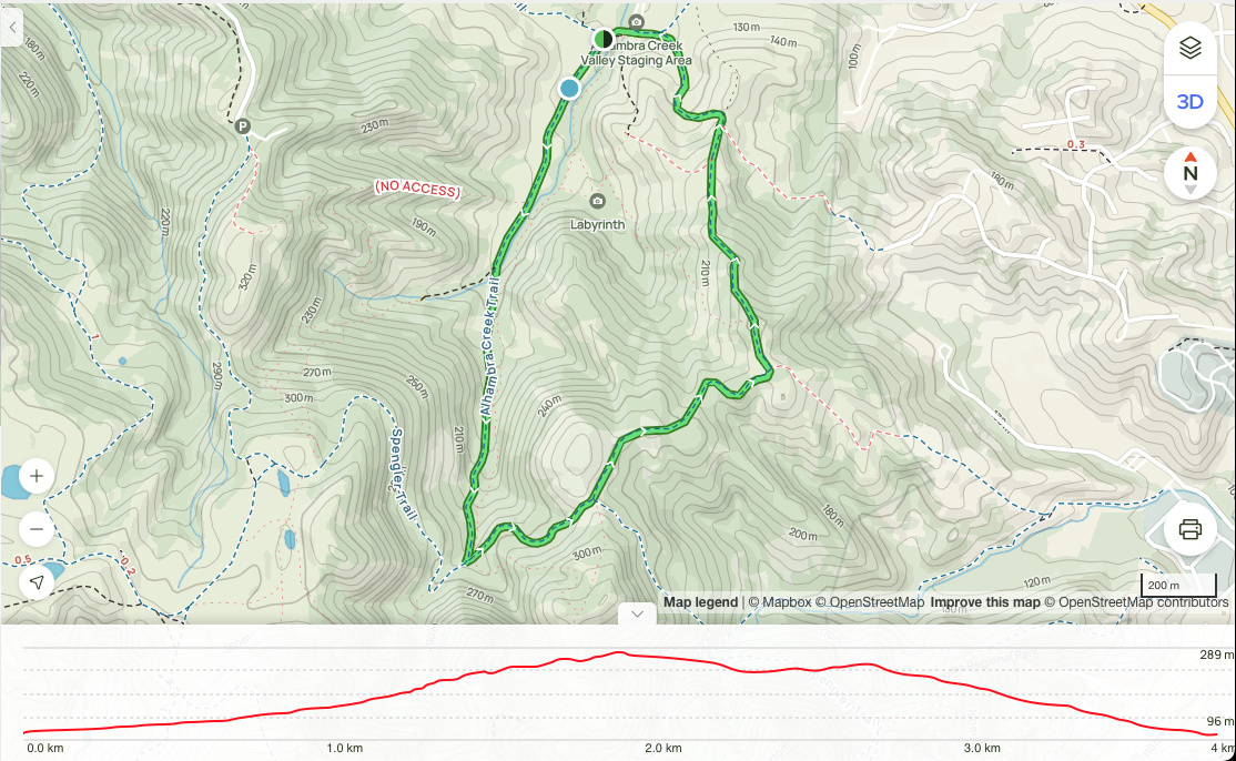
Location: Briones Regional Park — 2537 Reliez Valley Road, Martinez, CA
Meeting Point: Alhambra Creek Staging Area — Gather at the southwest end of the parking lot, by the trail heads
Daily park entry fee (when kiosk is attended): $3 per vehicle; $2 per dog
Distance / elevation / duration: 2.4-mile loop / 574 ft / 1.5-2 hours
Difficulty: Easy to moderate, with elevation
Recommended for: All, with parental supervision for younger ones
Hike info: Hike info + Trail map
Park map: map
Awards: Highlander program progressive patch / Briones rocker patch
Contact: Hiking Chair Zhen (925-997-4889)
[ RSVP ]
Attire: Class B t-shirt and comfortable pants, layers, hiking boots/shoes
Bring: Sunscreen, cap, plenty of water and snacks, camera
Directions
Take I-680 N to CA-24 W. Take exit 14 from CA-24 W. Continue on Pleasant Hill Rd to Taylor Blvd, left on Grayson Rd, right on Reliez Valley Rd, then left on Brookwood Dr.
The hike
A great hike through nice cool shaded groves. A great choice for a hot day. Briones peak offers views from 1483 feet.
Discover this 3.9-km loop trail near Pacheco, California. Generally considered a moderately challenging route, it takes an average of 1 h 17 min to complete. This is a very popular area for birding, hiking, and horseback riding, so you'll likely encounter other people while exploring. The trail is open year-round and is beautiful to visit anytime.
Dogs are welcome and must be on a leash no longer than 6-foot long.
The trail
Take Alhambra Creek Trail To the Spengler Trail. Take Spengler to the Old Briones Road Trail. Continue to Briones Crest Trail to the Summit. There are many other trails in the area where you can deviate from if you wish.
For all in-person pack or den events and activities, please follow the SRVUSD COVID guidelines. If you are sick or are experiencing symptoms, please stay home and stay safe.
March 12: Pack hike: Lake Chabot via East Shore Trail
// Daylight savings start on this date! Adjust your clocks accordingly.
Date/Time: Sunday, March 12, 2023, at 10 AM - 12 PM
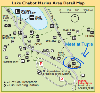
Location: Lake Chabot via East Shore Trail — 17600 Lake Chabot Rd, Castro Valley, CA 94546
Meeting Point: Turtle picnic area, at the fork in the trails (map)
Park fee: $5 per vehicle, $2 per dog
Distance / elevation / duration: 3.3-mile round trip / 200 ft / 1 hour 14 mins average
Difficulty: Easy, nearly flat, paved
Recommended for: All
Park: info + map
Hike info: Hike info + trail map
Directions: Google maps
Awards: Pack hike patch
Contact: David (415-613-3602)
Attire: Class B t-shirt and comfortable pants, layers, hiking boots/shoes
Bring: Sunscreen, cap, plenty of water and snacks, camera
[ RSVP ]
Hike Leader: David Copeland
Directions
Take I-680 S to I-580 W. Take exit 35 from I-580 W for Strobridge Ave. Turn right onto Stanton Ave (0.1 mi). Right onto Castro Valley Blvd (0.2 mi). Left onto Lake Chabot Rd (1.8 mi). Lake Chabot Regional Park main entrance will be on the right. Google maps
Allow for 35-40 mins to travel from San Ramon / Danville.
The hike
Enjoy scenic views of Lake Chabot on this family-friendly, paved path that follows the shoreline of the lake. This is the most accessible portion of the Lake Chabot.
The trail
This is a family-friendly, paved path that follows the shoreline of Lake Chabot. This is the most accessible portion of the Lake Chabot. The trail surface is paved asphalt and smooth. It is typically at least 8 feet wide. The majority of the trail is estimated to be in the mostly gentle (5% or less) grade category but there is a steeper section at about 1.4 miles when going north.
For all in-person pack or den events and activities, please follow the SRVUSD COVID guidelines. If you are sick or are experiencing symptoms, please stay home and stay safe.

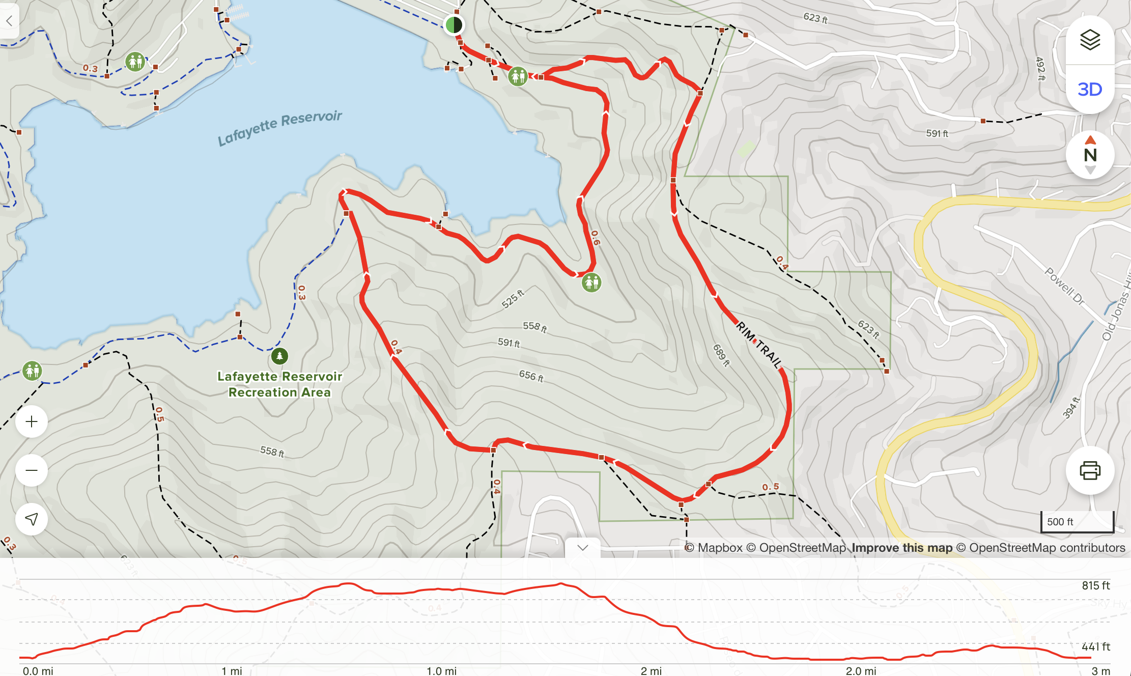
Jan 29: Lafayette Reservoir hike
Date/Time: Sunday, January 29, 2023, at 10am
Location: Lafayette Reservoir Recreation Area — 3849 Mt. Diablo Blvd. in Lafayette, CA
Meeting Point: Gather at the trail head, at the east end of the main parking lot
Daily park entry fee: $6; discounts for seniors and disabled persons
Distance / elevation / duration: 2.6-mile loop / 442 ft / 2 hours
Difficulty: Relatively easy, with elevation
Recommended for: All, with parental supervision for younger ones
Hike Info: Hike info / Trail map
Park map: map
Awards: Pack hike patch
Contact: Hiking Chair Zhen (925-997-4889)
Attire: Class B t-shirt and comfortable pants, layers, hiking boots/shoes
Bring: Sunscreen, cap, plenty of water and snacks, camera
Hiking Chair: Zhen Zhou
[ RSVP ]
The hike
This hike begins on the rim trail, leads to the big oak trail, then finishes on the paved lakeside trail. When finishing up on the lakeside trail hikers will begin to share the path with cyclists.
The trail: Lafayette Reservoir Rim, Big Oak, and Lakeside Nature Trail Loop
We'll hike this 2.6-mile loop trail near Lafayette, California. Generally considered an easy route, it takes an average of 1 h 12 min to complete. This trail is great for hiking and running, and it's unlikely you'll encounter many other people while exploring.
Dogs are welcome and must be on a leash.
The trail may be muddy and slippery after the rains.
October 16: Coyote Hills Trail Trekkers hike
Date/Time: Sunday, October 16, 2022, at 9:30am
Location: Coyote Hills Regional Park — 8000 Patterson Ranch Road, Fremont, CA 94555
Meeting Point: Outside Visitor Center
Fee: $5 per vehicle, $2 per dog
Distance / duration: 4 miles / 3 hours
Difficulty: Easy to moderate — a few short but steep hills
Recommended for: Tigers through Webelos
Hike Info: Hike info / Trail map below
Park map: map
Awards: Trail Trekkers Cub Scout Patch
Contact: Hiking Chair Zhen Zhou (925-997-4889)
[ RSVP ]
Attire:
- Class B and dress in layers
- Sturdy closed toe shoes
What to bring:
- Sunscreen, cap
- Plenty of water and snacks
Directions
Coyote Hills is at the west end of Patterson Ranch Road/ Commerce Drive in Fremont. From I- 880, take Highway 84 west, exit at Paseo Padre Parkway and drive north. Turn left on Patterson Ranch Road (parking fee).
The hike
This hike will introduce the pack to the marsh and hills of Coyote Hills Regional Park and give you a chance to see a great Visitor Center. It is about 4 miles long, with a few short but steep hills.
The trail
First Head into the marsh by crossing the park road at the south end of the Visitor Center parking lot. The kids will enjoy walking on the boardwalk. Stop at the wildlife viewing platforms to observe water fowl and possibly muskrats.
When the boardwalk ends, keep heading straight, gradually curving to the left, until you reach the D.U.S.T. Trail. Turn left on this trail, then right on Lizard Rock Trail. You will then join Bayview Trail, a paved bicycling trail which encircles the hills. Turn left on the Bayview Trail. When you reach Nike Trail, follow it up to a saddle. Once on the saddle, head south on the Hill Trail. After a short steep climb, you'll reach Red Hill Top, a hill formed of red chert. Watch out for poison oak among the rocks.
On a clear day, the views are great. You'll want to point out some of the sights - the salt evaporation ponds to the west, the marsh and boardwalk below you to the east (can you see where you were?), and some of the high peaks in the Bay Area. Some of these peaks are "Rim Rover" peaks which the boys can climb when they become Boy Scouts - Mission Peak just a little southeast, Mt. Tamalpais to the northwest (beyond San Francisco), and Mt. Diablo to the northeast.
Continue south, stopping at Glider Hill to watch people flying model gliders. Go slowly down the steep hill to Soaproot Trail and go left, passing above Dairy Glen, the group campsite. Turn left again, back to the Visitor Center (you'll be approaching the Visitor Center from behind.)
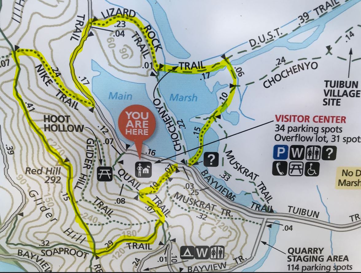
Alternate Routes
Longer or shorter loops can easily be made - consult the park map. The minimum requirement for this patch is to hike to Red Hill Top.
Visitor Center post-hike
Consider visiting the Visitor Center after the hike. Coyote Hills Visitor Center contains educational displays and exhibits as well as the Possum's Pocket Nature Store. The exhibits portray the Ohlone way of life and include a tule reed boat constructed by park staff and volunteers using Native American methods. Other exhibits cover the park's natural history and wildlife. Open 10am - 4pm on Sundays.
For all in-person pack or den events and activities, please adhere to the pack's COVID statement. If you are sick, are experiencing symptoms, or may have been exposed to COVID-19, please stay home and stay safe.
September 25: Las Trampas Highlander hike
Date/Time: Sunday, September 25, 2022, at 9:30am
Location: Las Trampas — San Ramon
Meeting point: Las Trampas public parking — at the end of Bollinger Canyon Rd in San Ramon
Distance / elevation / duration: 1.5 - 2.7 miles / 575 ft
Difficulty: Easy to moderate
Hike info / map: Hike info | hike map
Awards: Highlander program: Las Trampas rocker patch
Hiking Chairs: Kushal K., Zhen Z.
Attire: Class B or regular t-shirt, approved face covering, cap, sturdy closed toe shoes
What to bring: Plenty of water and snacks, sunscreen, binoculars, camera
[ RSVP ]
Getting there
Take Bollinger Canyon north, past Crow Canyon. Continue about 4.5 miles to the trailhead at the end of the road. If you've been to Little Hills Ranch, keep going past its parking lot. Turn left on Rocky Ridge Road. Parking lot is at the end on the left. See map.
The hike
Las Trampas (Spanish for the traps) has two distinct areas, each with its own personality. Rocky Ridge, on the west side of the valley, is known for views in all directions, unusual rocks and green rolling hills lightly forested with California bays, oaks and maples. The wildflower display on the hills just off the ridgeline is an east bay favorite. The Las Trampas Ridge, to the east, is quite different, featuring a plant community dominated by chamise with other chaparral plants such as manzanitas and coyote brush.
The trail
Start on Bollinger loop trail for about 0.8 miles then turn right on Bollinger Canyon Trail and stay right and on it for about 0.3 miles. Then turn right on Las Trampas Ridge Trail and keep going for about 0.8 miles, and finally right on Chamise Trail towards the staging area. This final stretch is about 0.5 miles.
Total distance is approx 2.7 miles with about 575 ft gain in elevation. If it gets too hot, we'll cut short the hike to about 1.5 miles.
August 14: Sand Hill Trail hike
Date/Time: Sunday, August 14, 2022, at 9am
Location: Sand Hill Trail — Danville
Meeting point: Sycamore Valley Elementary School parking lot — 2200 Holbrook Dr, Danville, CA 94506
Distance / elevation / duration: 2.1 miles / 449 ft / 1 hour 5 mins
Difficulty: Easy
Hike Info: Hike info
Awards: Pack hike patch
Hiking Chairs: Kushal K., Zhen Z
Attire: Class B t-shirt, approved face covering, sturdy closed toe shoes
What to bring: Plenty of water and snacks, binoculars, camera
Getting there
From I-680, exit at Sycamore Valley Road in Danville. Follow Sycamore Valley Road for 1.5 miles, then continue on to Camino Tassajara. Turn left onto Sherburne Hills Road, then turn right to find parking.
The hike
Generally considered an easy route, it takes an average of 1 h 5 min to complete. This is a very popular area for birding, hiking, and mountain biking, so you'll likely encounter other people while exploring. The trail is open year-round and is beautiful to visit anytime. Dogs are welcome, but must be on a leash.
Scouts and participating siblings will receive a patch.
For all in-person pack or den events and activities, please adhere to the pack's COVID statement. If you are sick, are experiencing symptoms, or may have been exposed to COVID-19, please stay home and stay safe.
July 10: Hoot Owl Hike

// WHEN
Sunday, July 10, 2022
8-10pm
// WHERE
Sycamore Grove Park
Nature Area Entrance
Livermore, CA 94550
See GPS coordinates: https://goo.gl/maps/tGPnPCzq5Hu
// RSVP
by July 6, 2022
First come first served
// WHO
Pack 1776 Scouts, 5 years and above, accompanied by an adult/guardian.
No more than one parent/guardian per Scout. Up to 2 parents per family, if more than one P1776 Scout in the family participating.
One parent may arrange and agree to be responsible for 2 or more Scouts from same or different households.20 participants total.
If additional spots are available after July 6, then sign-up will open up to additional family members (parents, siblings).
// COST
Free for Pack 1776 Scouts.
Price $5 per parent (or sibling if extra spots after 7/6).
Bring check, payable to Pack 1776, to the hike.
// DETAILS
1.5 miles
Allow about 1.5-2 hours for program and hike
// BRING
Sturdy shoes like hiking boots or tennis shoes. You will be walking on dirt and gravel trails.
Layers of clothing – when the sun goes down it may get cold, even in the summer.
Drinking water in a reusable bottle that you can carry with you.
// DO NOT BRING
These items may not be taken on the night hike – you will need to leave these items in your car:
Flashlights
Cameras with flashes
Food
Walking sticks
Cell phones
// IMPORTANT
Parents, please ensure that your Scouts are quiet, engaged, and follow directions throughout the hike, for an enjoyable experience for all.
// LINKS
https://www.larpd.org/hoot-owl
https://ggacbsa.org/wp-content/uploads/2020/07/Hoot-Owl-Sycamore-Grove-Regional-Park.pdf
[ Sign up ]


