November Hike – Mt Diablo
 Date: Sunday, November 7, 2010
Time: 10:00am
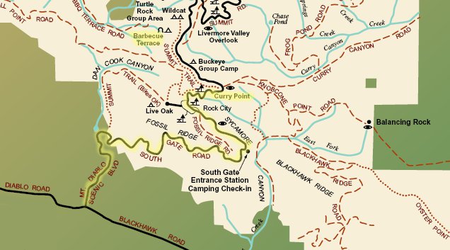
Location: Mt. Diablo State Park - Meet at Curry Point Parking (South Gate Road)
Pack 1776 families,
Next hike will coincide with our camping trip. I hope that you will be camping that week-end. If not, you can still enjoy the hike.
Note:
- Avoid a heavy breakfast.
- Bring a bottle of water.
- Entrance fee $10 per car.
- Car pool to reduce vehicle emissions and charges.
- Layer your clothes - it might be cold.
Directions: At the Park boundary the road becomes South Gate Road. Continue up the mountain, past the entrance station to just past Rock City. Park in the Curry Point view area on the left.
Bernard Kiriakos
Hiking Chair
Outdoor October Pack Meeting & Overnight Stay
Oct 9 - Last minute reminders: Bring flashlight, chairs, warm clothes. Print placard for your car. Here's the campfire program. See you all there.
Sep 29 Update: Conditions have changed. We will have the outdoor Pack Meeting but won't stay overnight. The hike on the next morning will be rescheduled. Check with your den leaders for detail.
 Date: Saturday, October 9, 2010
Time: See agenda below
Location: Bort Meadow at Anthony Chabot Regional Park (map)
Attire: Class A uniforms for all scouts for the Campfire Program
Pack 1776 Scout Families,
One of the highlights of our scouting year is celebrating our third annual outdoor pack meeting at Bort Meadow Group Camp just north of Anthony Chabot Campground in Castro Valley. All scouts & families are welcome! Details below. Please RSVP via evite, so we can plan accordingly.
We look forward to seeing everyone!!
Yours in Scouting,
Assistant Cubmaster & Master of Ceremonies
John Pluth
[stextbox id="info" caption="Schedule" align="center" collapsed="true"]Saturday, Oct 9:
2:00pm Set up time. Scouts & families start arriving.
2:30-4:00pm Den time. Have a den meeting and practice your skits.
3:30pm Burgers, gourmet sausages & hot dogs will start to be served.
4:30pm Campfire program will promptly start. We are planning on a campfire, s'mores, dens skits and lots of fun! Each den is to perform a skit, lead a song, have some “cheers” & perform some run-ons.
5:30pm Overnight stay is optional.
Sunday, Oct 10:
9:00am Breakfast will be served - Pancakes, juice & coffee.
10:00am Pack hike (whether you camped or not) from Bort Meadow. You can come back for the hike even if you can’t camp overnight.[/stextbox] [stextbox id="info" caption="What to Bring" align="center" collapsed="true"]For pack meeting: Print this car placard and place it on the dashboard of your car, chairs, warm clothes, and a flashlight.
For camping: Tent, sleeping bag, sleeping pad / air mattress, pillow, extra clothes, sundries, etc.
For hiking: Long pants, sun screen, water, snacks, binoculars, camera, etc.[/stextbox] [stextbox id="info" caption="Related Awards and Achievements" align="center" collapsed="true"]All: Year of celebration award Outdoors #4; Outdoor activity award #1, 4, 10; Hiking belt loop #2, 3
Tiger: Achievement 5g
Wolf: Achievement 2f; Elective 11f, 18g, 23a & b
Bear: Achievement 3i, 9e; Elective 25b & c & d
Webelos: Outdoorsman 1, 2, 3[/stextbox] [stextbox id="info" caption="Directions" align="center"]From San Ramon,
· Take Crow Canyon West (past the 680, approx 7.5 miles)
· Turn Right onto Cull Canyon (go .2 miles)
· Turn Left onto Heyer Ave (go 1 mile)
· Turn Right onto Redwood Rd (go 7.3 miles)
· Turn Left into Bort Meadow Campground
· Pass through gate & follow dirt road to Bort Meadow staging area
View Larger Map[/stextbox]
Sunol Regional Wilderness Hike Wrap-up
 I want to recognize and congratulate the following scouts:
* Jack P
* Jacob K
* Ethan M
* Jared O
for finishing a very arduous four mile hike. The hike took more than 3 hours to complete. We climbed to an altitude of 1360 feet and had to go down on relatively steep slopes.
Special thanks for all the parents who participated in this hike and assisted me in finding our way down.
Bernard Kiriakos
Hiking Chair
September Hike – Sunol
 Date: Sunday, September 19, 2010
Time: 1:45pm - 4:15pm
Location: Sunol Regional Wilderness (map)
This 4 mile loop hike is moderately easy, although there are a few steep stretches. Trailhead elevation is about 410 feet. The park's highest trail reaches about 2300 feet. The featured hike climbs to about 1360 feet, then descends back to the trailhead. Total elevation change is about 1000 feet.
[stextbox id="info" caption="Hike Statistics" align="center"]Distance: 4 miles
Time: 2.5 hours
Trail surfaces: Dirt trails and fire roads.
Be sure to read: Hike info and map[/stextbox] [stextbox id="info" caption="Directions" align="center"]From Interstate 680 in Alameda County, exit Calaveras (exit 21a). Follow the brown "parks" signs. (If you've exited southbound, stay in the left lane of the exit ramp, turn left, drive under the freeway and then stay in the left lane through a stop sign, to remain on Calaveras.) Drive south on Calaveras about 4 miles to the junction with Geary, and turn left. Continue on Geary almost 2 miles to the park entrance kiosk, then continue past the visitor center to an unmarked dirt lot on the left. Park at Visitor Center.[/stextbox] [stextbox id="info" caption="What to Bring" align="center"]Water, snack (granola bars, trail mix, fruit), sun screen, entrance fees.
Binoculars, camera, layer your clothes.[/stextbox] [stextbox id="alert" caption="Note" align="center"]Please arrive at 1:45 PM as the hike starts promptly at 2 PM![/stextbox]
May Hike Wrapup
Thanks to all scouts and parents who went on a great hike today.
I uploaded some photos to SmugMug. If you took some pictures, please feel free to upload them to the same gallery.
We will be emailing shortly the information for the June hike.
Thank you!
Bernard & Eka
Hiking chairs
May Hike – Mt Diablo (Updated)
May 16: Updated directions and note sections.
Date: Saturday, May 22, 2010
Time: 12:00pm - 2:30pm
Location: Mt Diablo State Park
Trailhead: Curry Point, South Gate Road
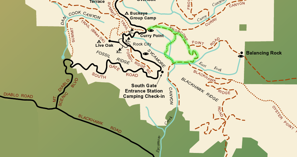
Trail detail: It is an easy 3.3 loop trail with an elevation gain of 500 feet. Take the Knobcone Point Road from the parking lot for about 1 mile to Black Hawk Trail. Turn right and continue to Sycamore Creek Road. Turn right again to Devils Slide Trail and turn right. Begin climb out of Sycamore Canyon on this wonderful singletrack trail as it heads back to Knobcone Point Road, where you turn left back to the trailhead. See highlighted trail in map.
Highlights: During our hike, we will review what we learned about all three types of rocks (from our camp at Del Valle). The Cub Scouts will be surprised to learn that Mt Diablo is sedimentary in origin. It was laid down millions of years ago on the floor of the ocean. Within the last one to two million years, a piece of hard, red 160-million-year-old Franciscan rock was pushed up through six to eight miles of overlying rock and soil, tilting and distorting the rock layers and in some places turning them completely upside down. As a result, the fossilized remains of many sea creatures have been discovered here.
Directions: From Crow Canyon Rd continue onto Blackhawk Road. It becomes Diablo Road. Go to Mt. Diablo Scenic Boulevard and turn right. At the Park boundary the road becomes South Gate Road. Continue up the mountain, past the entrance station to just past Rock City. Park in the Curry Point view area on the left.
Note: This is a great hike but part of it is arduous (avoid heavy lunch). Please bring a bottle of water and sun screen. After the hike, we could go for an ice-cream.
What to bring:
- Park brochure and map.
- Entrance fee $10 per car. You can car pool and reduce vehicle emissions and charges.
- Food, snack (granola bars, trail mix, fruit), water.
- Binoculars, camera, sunscreen.
- Layer your clothes.
April Hike – Lake Del Valle
 Date: Sunday, April 18, 2010
Time: 1:30pm - 3:30pm
Location: Lake Del Valle, Livermore
This 3.8 mile loop hike is easy. Trailhead elevation is around 745 feet. Top elevation for the featured hike is about 1130 feet. Trails climb at reasonable grades, and the total elevation change is about 700 feet. Folks new to hiking can shorten the featured hike, or choose an easier, mostly level walk along the shores of the reservoir.
[stextbox id="info" caption="Hike Statistics" align="center"]Distance: 3.8 miles
Time: 2 hours
Be sure to read: Hike info and map[/stextbox] [stextbox id="info" caption="Directions" align="center"]From Interstate 580 in Alameda County, exit Central Livermore/North Livermore Avenue (exit 52b). Drive south on North Livermore, which turns into South Livermore, passes through downtown, makes a sharp left curve, and turns into Tesla Road (about 3.5 miles from 580). Just past the curve, look for the brown "parks" sign and turn right onto Mines Road. Drive about 3.5 miles, at which point Mines Road veers left. Follow the brown parks signs, and stay straight on Del Valle Road about another 3.5 miles to the park entrance kiosk, on the right side of the road. Park near the snack bar if possible.[/stextbox] [stextbox id="info" caption="What to Bring" align="center"]Food, snack (granola bars, trail mix, fruit), water.
Binoculars, camera, layer your clothes.[/stextbox] [stextbox id="alert" caption="Note" align="center"]All scouts and their parent who are not camping should meet us at the camping ground.[/stextbox]
March Hike – Tilden Park
Date: Sunday, March 21, 2010
Time: 1:30pm - 3:30pm
Location: Tilden Nature Study Area, Tilden Regional Park, Berkeley
A view of Mount Tamalpais rising from San Francisco Bay will be the reward for hiking to the top of Wildcat Peak in Tilden Park. This trail loops through eucalyptus and oak forests, up moderately steep hills, then back to one of the best nature study areas in the Bay Area.
[stextbox id="info" caption="Hike Statistics" align="center"]Distance: 2.5 miles
Time: Allow about 2 hours
Grade: Mostly gentle with some moderately steep grades near the peak
Be sure to read: Hike info, area brochure and map[/stextbox] [stextbox id="info" caption="Directions" align="center"]From Highway 24 take the Fish Ranch Road Exit (just east of the Caldecott Tunnel); go north about 1 mile to Grizzly Peak Blvd., turn right; stay on Grizzly Peak about 12.5 miles; turn right on Canon Drive, go about .10 mile and veer left on Central Drive, following signs to the Little Farm and Nature Study Area.[/stextbox] [stextbox id="info" caption="What to Bring" align="center"]Food, snack (granola bars, trail mix, fruit), water.
Binoculars, camera, layer your clothes.[/stextbox]
Jaguar Hike – Mission Accomplished
Today's hike was not a comfortable one. After 75 minutes of walking briskly we were soaking wet.
But hikes are not supposed to be easy.
This hike was a good preparation for scouts who one day will interview the Jaguar people in the Amazon forest.
The jaguar hike (aka Lafayette reservoir) was a great character building event centered on endurance.
Eka and I want to recognize the following scouts who completed it:
- Warren H
- Andrew K
- Jacob K
- Colin H
- Thomas M
- Matthew I
CANCELLED: December Field Trip – Wildcat Peak
 Date: Sunday, December 13, 2009
Time: 12:00 noon - 2:00PM
Location: Tilden Nature Study Area, Tilden Regional Park, Berkeley
Hello Pack 1776 Families,
Eka and I decided to cancel the hike this coming Sunday. We took this decision chiefly based on safety reasons.
The weather forecast predicts rain for Friday, Saturday and Sunday. This hike is fairly difficult (compared to previous ones) and muddy conditions will make it even harder.
Please contact us if you have any questions or suggestions.
Bernard & Eka
