April 16: Pack Hike – Briones Park
Location: Briones park, Alhambra Creek Trai
Attire: Class B
Date: Sunday, April 16, 2023
Time: 10:00 AM PT - 12:00 PM PT
Location: Briones Regional Park — 2537 Reliez Valley Road, Martinez, CA
Meeting Point: Alhambra Creek Staging Area — Gather at the southwest end of the parking lot, by the trail heads
Daily park entry fee (when kiosk is attended): $3 per vehicle; $2 per dog
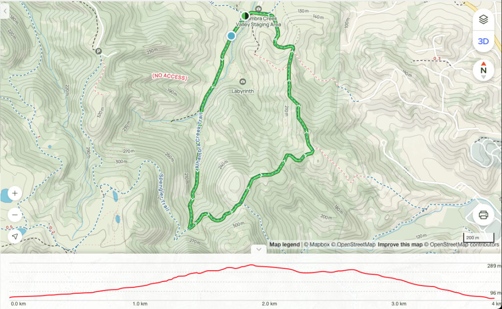
Distance / elevation / duration: 2.4-mile loop / 574 ft / 1.5-2 hours
Difficulty: Easy to moderate, with elevation
Recommended for: All, with parental supervision for younger ones
Hike info: Hike info + Trail map
Park map: map
Awards: Highlander program progressive patch / Briones rocker patch
Contact: Hiking Chair Zhen (925-997-4889)
[ RSVP ]
Attire: Class B t-shirt and comfortable pants, layers, hiking boots/shoes
Bring: Sunscreen, cap, plenty of water and snacks, camera
Directions
Take I-680 N to CA-24 W. Take exit 14 from CA-24 W. Continue on Pleasant Hill Rd to Taylor Blvd, left on Grayson Rd, right on Reliez Valley Rd, then left on Brookwood Dr.
The hike
A great hike through nice cool shaded groves. A great choice for a hot day. Briones peak offers views from 1483 feet.
Discover this 3.9-km loop trail near Pacheco, California. Generally considered a moderately challenging route, it takes an average of 1 h 17 min to complete. This is a very popular area for birding, hiking, and horseback riding, so you'll likely encounter other people while exploring. The trail is open year-round and is beautiful to visit anytime.
Dogs are welcome and must be on a leash no longer than 6-foot long.
The trail
Take Alhambra Creek Trail To the Spengler Trail. Take Spengler to the Old Briones Road Trail. Continue to Briones Crest Trail to the Summit. There are many other trails in the area where you can deviate from if you wish.
For all in-person pack or den events and activities, please follow the SRVUSD COVID guidelines. If you are sick or are experiencing symptoms, please stay home and stay safe.


