December Hike – Sycamore Grove
 Date: Sunday, Dec 15, 2013
Time: 9 am
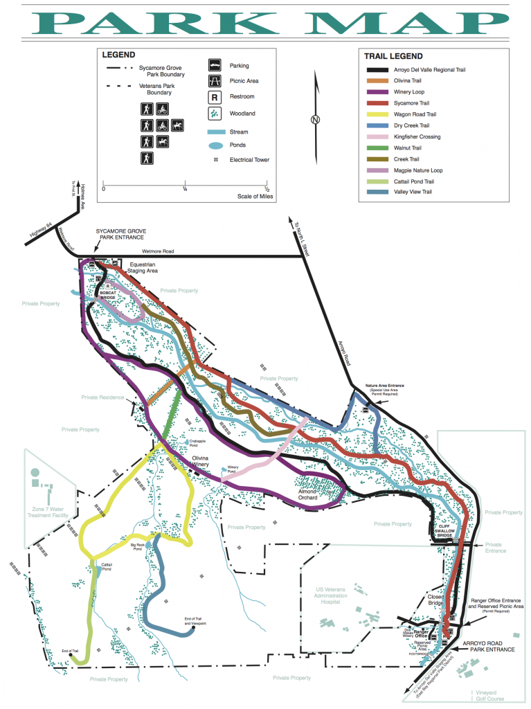
Location: Sycamore Grove Park (map), Livermore
Meeting Point: Whetmore Road Entrance Parking lot (8:30 am)
Attire: Class B
Awards: Trail Trekkers Cub Scout Patch/Progressive Hike Award
Parking Fee: $5 per vehicle
Must read: Hike info
Contact: Hiking Chairs Ajay Hampapur & Teresa Noble
What to bring:
- binoculars, camera
- layers of clothing – this hike can be cold and windy
- water and snacks (granola bars, trail mix, fruits)
Details
Every inch of this park is alive with life - in the air, in the grass, even in puddles. Begin your search for signs of wildlife at the Wetmore Road entrance. Follow the paved path until you come to the first sign designating the Nature Area. Turn left onto the broad trail that crosses the usually dry Arroyo. Follow this nature trail through the sycamore grove until you reach the park boundary. While you are here, be sure to pause often and listen for the sounds of reptiles and rodents in the grass. If you are lucky and very patient you might even see an animal. Near the wet areas be sure to look for great blue herons. Don't forget to look up!
About The Park
The park is home to a variety of wildlife. Along the Arroyo Del Valle you might see frogs, pond turtles, dragonflies, ducks or even muskrats. In addition to this riparian area there are grassland and oak woodland habitats. Deer, ground squirrels, butterflies, lizards and birds such as red-tail hawks, white-tail kites, scrub jays, magpies and meadowlarks are just few of the animals you might spot in these areas.
November Hike – Coyote Hills
Date/Time: Sunday, Nov 17, 2013, 9:00am
Location: Coyote Hills Regional Park
Distance: 4 miles round trip
Time: Allow 2-3 hours
Grade: A few short but quite steep grades
Attire: Class B uniform
Award: Trail Trekkers patch
Parking & Fees: Parking at the Visitor Center. $5 parking fee.
Must read: Hike info
Meeting Point: Coyote Hills Visitor Center
Contact: Hiking Chairs Ajay Hampapur & Teresa Noble
Bring:
- binoculars, camera
- water and snacks: granola bars, trail mix, fruits
- layers of clothing - this hike can be cold and windy
Details
Salt Flats, water fowl and wind gliders if we are lucky. No trip to Coyote Hills is complete without taking a little time to explore the Visitor Center. Excellent exhibits in the Visitor Center depict the Ohlone Indian culture and the natural history of the Coyote Hills area. Important Note: We meet approximately half an hour prior to the hike at specific hiking staging areas. As a courtesy to all hikers, we leave promptly at the scheduled times!
Bring the entire family !
About The Park
Coyote Hills Regional Park was dedicated to public use in 1967. Comprised of nearly 978 acres of marshland and rolling grassland covered hills, this busy park is located along the eastern shore of San Francisco Bay, northwest of the cities of Fremont and Newark. The most popular visitor activities by far are bicycling, walking, bird watching, jogging, nature exploration, and picnicking. Well used every season of the year, spring, summer, and fall tend to be the most popular. But the park's winter beauty is wonderful to behold.
History
The East Bay area's original inhabitants were the ancestors of the Ohlone Indians, hunters and gatherers whose skills enabled them to live well off the land's natural bounty. In those days, tule elk roamed the land, condors soared overhead, and sea otters and fish were abundant in the Bay. At Coyote Hills Regional Park, some of this rich wetland is preserved, along with 2,000-year old Tuibun Ohlone Indian shellmound sites with fascinating archaeological resources.
The park's rich and varied history also includes Mission and settler ranching and farming activities, salt production, a duck hunting club, a dairy, rock quarrying, a military NIKE missile site, and a biosonar research facility. Now a Regional Park, this area is preserved for recreation, and educational and nature experiences for all to enjoy.
To Reach The Park
Coyote Hills Regional Park is located at 8000 Patterson Ranch Road, Fremont, CA 94555. The closest BART station is the Union City BART station. The park's main entrance is at the west end of Patterson Ranch Road/Commerce Drive in Fremont. From I-880, take Highway 84 west, exit at Paseo Padre Parkway, turn right, and drive north about one mile. Turn left on Patterson Ranch Road. This is the park's entrance road and will take you to the picnic areas and visitor center. Parking fees may apply.
April 2013 Hike to Redwood Regional Park
Date: Sun April 21, 2013 (New Date!!!)
Time: 8:30 AM to 12:30 PM
Meeting Point: Parking lot of Canyon Meadow Staging Area.
Attire: Class B
Awards: Trail Trekkers Cub Scout Patch/Progressive Hike Award.
Fees: Park Entrance Fees - $5.00
Hike Details: http://www.sfbac.org/files/images/pdfs/hiking/RedwoodCreek.pdf
Park Details: http://www.ebparks.org/parks/redwood.htm
Contact: Hiking Chair - Sachin Sheth (925.968.9940)
Distance: 6 mile loop hike.
Category: Easy with some short steep climbs
Hiking time: ~ 4 hours.
GPS Coordinates: 37.805597,-122.146747
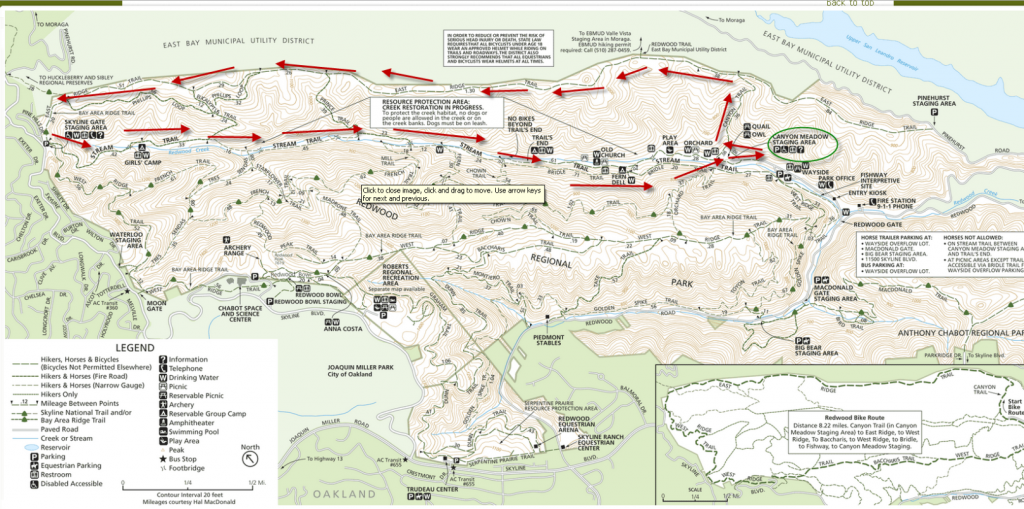
Trail Map:
What to bring?
- Long pants
- Dress in Layers
- Snack
- Water
- Binoculars
Directions:
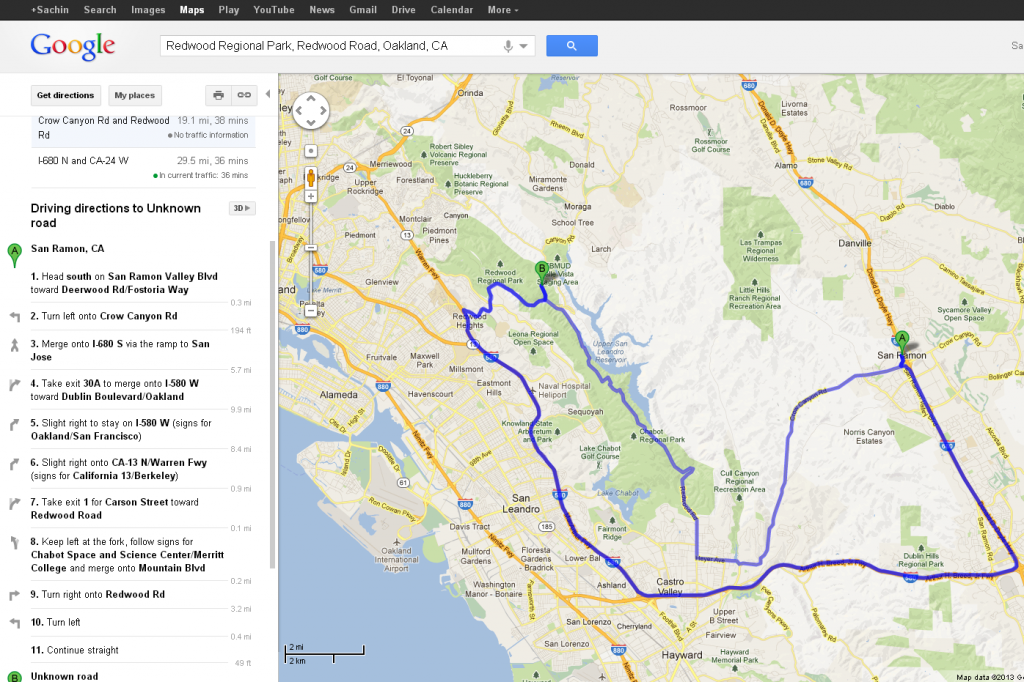
Although, the fastest way to get there is by going though I-680 and I-580, the alternate route shown on the map in a lighter blue color (Crow Canyon Road to Redwood Road) is shorter and way more scenic.
Note that here are several entrances to Redwood Regional Park. The main entrance, Redwood Gate, is on Redwood Road in Oakland about two miles east of Skyline Blvd. In Oakland on Highway 13, take the Redwood Road exit and go east (uphill). At the top of the hill you will cross Skyline Boulevard and pass the Skyline Ranch Equestrian Center on the right. Farther along you will pass Piedmont Stables on the left. Big Bear Staging Area will be on the right about one and one-half miles from Skyline Boulevard, followed by MacDonald Staging Area on the right and Redwood Gate on the left (seasonal parking fee). Continue to the Bear Creek Staging Area and park there.
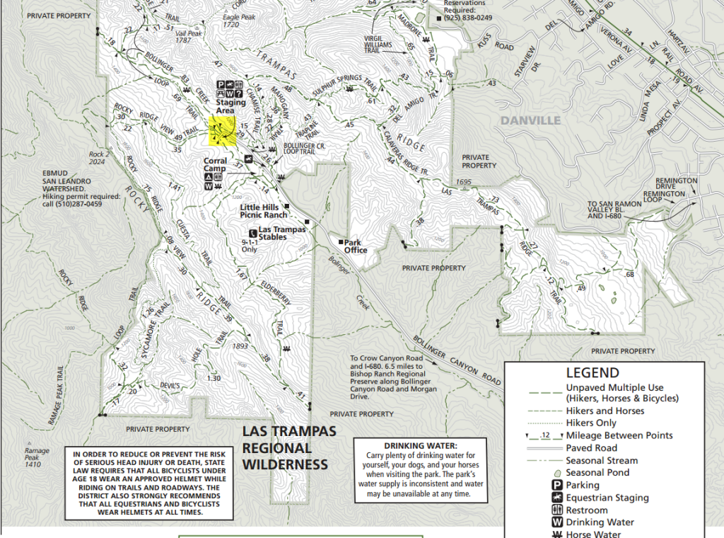
March Hike – Las Trampas Rocky Ridge Loop Trail
Las Trampas Regional Wilderness is close to home and has great hiking, with excellent views, wildflowers and streams in spring, with bird viewing opportunities as well.
 Date: Sunday, March 17, 2012
Time: 8:45 am – 11.45 am
Location: Las Trampas Regional Wilderness, Danville
Meeting Point: Corner of parking lot right by the information displays.
Attire: Class B
Awards: Highlander patch and/or the Las Trampas Rocker patch.
Fees: None
Must read: Hike info and trail map
Contact: Hiking Chair - Sachin Sheth (925.968.9940)
Details
Distance, category, and difficulty:
Easy to Moderate with ~1100 ft of elevation gain. Total distance ~ 4.5 miles.
Hiking time:
~3 hours
Exposure:
Exposed
Trail surfaces:
Fire roads and dirt trails
What to bring:
- Binoculars
- Long pants
- Dress in layers – please wear weather appropriate attire.
- Snacks
- Water
Getting there:
From Highway 680: Take the Crow Canyon Road exit. Drive west on Crow Canyon for about 1 mile, then turn right (north) onto Bollinger Canyon Road. Continue about 4.5 miles to the trailhead at the end of the road.
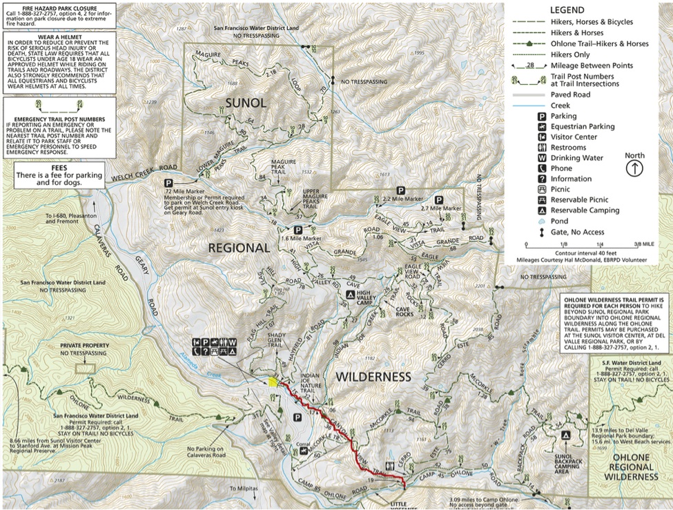
February Hike – Little Yosemite, Sunol Region Wilderness
Little Yosemite is a scenic gorge on Alameda Creek about two miles upstream from park headquarters. Cub scouts will enjoy this beautiful hike with its gorgeous waterfalls and pools.
 Date: Sunday, Feb 24, 2012
Time: 8:45 am – 12:00 pm Time changed!
Location: Little Yosemite, Sunol Regional Wilderness, Sunol
Meeting Point: Corner of parking lot right by the trailhead.
Attire: Class B
Awards: Trail Trekkers Cub Scout Patch/Progressive Hike Award.
Fees: Park Entrance Fees - $5.00
Must read: Hike info
Contact: Hiking Chair - Sachin Sheth (925.968.9940)
Details
Distance, category, and difficulty:
Easy, 4.4 miles
Hiking time:
~3 hours
Exposure:
Exposed
Trail surfaces:
Fire roads and dirt trails
What to bring:
- Binoculars
- Long pants
- Dress in layers – please wear weather appropriate attire.
- Snacks
- Water
Getting there:
• Go south on I-680 and exit at Calaveras Road/Highway 84 just south of the town of Pleasanton. Turn left onto Calaveras Road and proceed to Geary Road, which leads directly into the park.
GPS Coordinates* for Trailhead:
Latitude 37°30'55.58"N
Longitude 121°49'50.27"W
January Hike to Wildcat Peak
Date: Sunday, January 20, 2012
Time: 9:30am – 11:30am
Location: Tilden Nature Area, Tilden Regional Park, Berkeley
Meeting Point: Near the sign you see below.
Attire: Class B
Awards: Trail Trekkers Cub Scout Patch/Progressive Hike Award.
Must read: Hike info
Contact: Hiking Chair Sachin Sheth (Email: sdsheth@yahoo.com Tel: 925.968.9940)
A view of Mount Tamalpais rising from San Francisco Bay will be the reward for hiking to the top of Wildcat Peak in Tilden Park. This trail loops through eucalyptus and oak forests, up moderately steep hills, then back to one of the best nature study areas in the Bay Area.
[stextbox id="info" caption="Hike Statistics" align="center"]Distance: 2.5 miles
Time: Allow about 2 hours
Grade: Mostly gentle with some moderately steep grades near the peak
More Detail: Hike info, area brochure and map[/stextbox] [stextbox id="info" caption="Directions" align="center"]From Highway 24 take the Fish Ranch Road Exit (just east of the Caldecott Tunnel); go north about 1 mile to Grizzly Peak Blvd., turn right; stay on Grizzly Peak about 12.5 miles; turn right on Canon Drive, go about .10 mile and veer left on Central Drive, following signs to the Little Farm and Nature Study Area.[/stextbox] [stextbox id="info" caption="What to Bring" align="center"]Food, snack (granola bars, trail mix, fruit), water.
Binoculars, camera, layer your clothes.[/stextbox] [stextbox id="info" caption="Other Information" align="center"]There is plenty to do for younger siblings in the nature area; Bring an extra pair of socks as the scouts may get their feet wet; Rain cancels this hike.[/stextbox]
December Hike to Sycamore Grove, Livermore
 Sycamore Grove is a great place to hike/bike and is stroller friendly. The last part of the hike will be a ‘quiet’ stroll during dusk.
Date: Sunday, Dec 9, 2012
Time: 1:30 pm – 4.45 pm
Location: Sycamore Grove (Wetmore Road Entrance), Livermore
Meeting Point: Corner of parking lot right by the trailhead.
Attire: Class B
Awards: Trail Trekkers Cub Scout Patch/Progressive Hike Award.
Fees: Park Entrance Fees - $5.00
Must read: Hike info
Contact: Hiking Chair Sachin Sheth (Email: sdsheth@yahoo.com Tel: 925.968.9940)
Details
Distance, category, and difficulty:
Easy, 5.8 miles
Hiking time:
~3 hours
Exposure:
Exposed
Trail surfaces:
Paved and dirt trails (stroller friendly)
What to bring:
- Flash light
- Binoculars
- Long pants
- Dress in layers – please wear weather appropriate attire.
- Snacks
- Water
Getting there: (Locator map)
• From the north: Interstate 680 S to 580 E, exit Portola (exit 52a). Drive south on Portola about 0.5 mile, then turn right onto North L Street. Continue south (North L becomes South L, then Arroyo Road), altogether about 2.2 miles, then turn right onto Wetmore. Drive about 0.7 mile, then turn left into the park.
• From the south: Interstate 680 in Alameda County, exit CA 84 east. Drive about 6.5 miles east on CA 84, then turn right onto Holmes. Drive just 0.2 mile, and shortly after the road turns sharply left (becoming Wetmore), turn right into the park.
GPS Coordinates* for Trailhead:
Latitude 37°38'41.64"N
Longitude 121°46'55.33"W
October Hike and Enrichment Programs
Date: Sunday, Oct 28, 2012
Time: 10:30 am (please see other meeting times/locations below).
Location: Multiple locations in Golden Gate National Recreation Area, Marin and vicinity
Attire: Class B
Awards: Wildlife conservation belt loop, Trail Trekkers Cub Scout Patch/Progressive Hike Award. Scouts can also choose to become Junior Rangers.
Fees: None (only bridge tolls)
Sign up: Evite (Check your spam/junk mail folder if you haven't received it)
Must read: Hike info
Important Notes: Rain/Heavy Fog cancels the event. Parking can be an issue on Hawk hill so arrival by 11.30 am is recommended to avoid the walk uphill.
Contact: Hiking Chair Sachin Sheth

Destinations
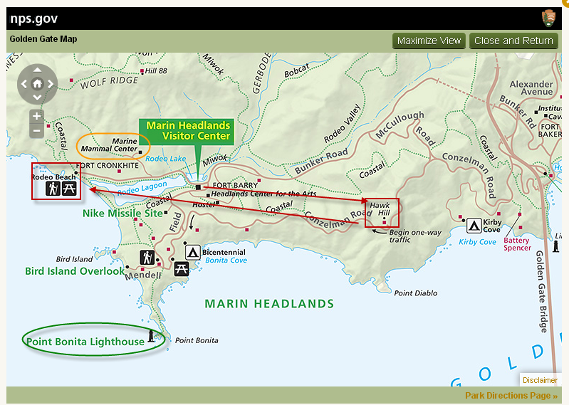
(1) Marin Headlands Visitor Center (2) Hawk Hill (3) Rodeo Lagoon
Meeting Point (s)
Marin Headlands Visitor Center (10.30 AM)
Hawk Hill (11.30 AM)
Rodeo Beach Picnic Area (2.30 PM)
Details
At the Marin headlands visitor center we will review the exhibits and get a Junior Ranger booklet for the kids. The visitor center opens by 9.30 AM, so feel free to arrive early. At 11.15 AM we will head out to Hawk hill for the hawk talk. After the talk ~1.15 PM participants can head to the picnic area on Rodeo Beach by the trail head or choose to get a bite to eat in Sausalito. Hike will begin at 2.30 PM.
Marin Headlands Visitor Center
The Center's exhibits introduce the Headland's natural history and trace the area's human history from the days of the Miwoks through modern times. You can see how a hawk flies and look through a microscope at the hidden life of local ponds. A Miwok shelter invites you inside to listen as present-day Coast Miwok people talk about their lives. A shop carries a good selection of books and field guides about the area. You can choose to become a Junior Ranger.
Halk Talk
The Hawk Talk and Banding Demonstration begins at noon - a GGRO volunteer speaks about hawk migration and identification, and what they do at the GGRO. Then at 1pm, a banding volunteer brings up a newly banded hawk, talks about the banding program, shows everyone the hawk, and lets it go in front of the crowd. It is a great way to learn about hawks and see one up close.
Rodeo Lagoon Hike
This is an excellent hike for those just beginning to take nature hikes with scouts. Rodeo Lagoon in the Golden Gate National Recreation Area is a natural lagoon formed by beach buildup. It generally catches fresh water that flows down the valley from ridges above, but waves occasionally wash over the beach during winter storms, forming brackish water.
Distance, category, and difficulty:
Easy, 1.5 miles
Hiking time:
< 1 hour. The kids can play on the beach after.
Exposure:
Exposed
Trail surfaces:
Dirt fire roads and trails
What to bring:
- Binoculars
- Long pants
- Dress in layers/Jacket – Please check weather forecast prior to hike.
- Lunch/Snacks – Please note that there are NO food vendors in the marin headlands
- Water
If it is not very cold, you may choose to wear sandals instead of shoes.
Getting there:
- Cross the Golden Gate Bridge and take the second exit Alexander Avenue.
- To Marin Headlands Visitor Center - Stay to the right on the exit ramp to get onto Alexander Ave. Turn left on Bunker Road (a brown sign saying "Marin Headlands Visitor Center" marks the intersection). Go through the one-way tunnel and drive approximately 2 miles. Turn left onto Field Road. The visitor center will be on the right side of the road.
- To Hawk Hill - Get in the left lane following signs that read "101 San Francisco." Turn left at the stop sign and cross under the freeway. Turn right onto Conzelman Road and drive 1.8 miles to Hawk Hill. Park alongside the road at the top of the hill, just before the road becomes one way. Walk up the west side of Hawk Hill past the locked gate. It's just a few hundred feet to the summit.
- To Rodeo Lagoon - After about 0.3 mile, turn left onto Bunker Road. There is a one-way tunnel which cuts under 101, and you may need to wait up to 5 minutes for your turn to travel through it (this is a great opportunity to put on sunscreen). From the other side of the tunnel, drive about 3 miles on Bunker Drive to the trailhead at the end of the road.
Get driving or public transit directions from Transit and Trails:
http://www.transitandtrails.org/trailheads/301
GPS coordinates* for trailhead:
Latitude 37°49'56.31"N
Longitude 122°32'19.83"W
November Hike – Briones Regional Park
 Date: Sunday, November 11, 2012
Time: 1:30pm - 3:30pm (Meet in the parking lot straight past the entrance kiosk)
Location: Briones Regional Park
Attire: Class B
Award: Highlander patch and the Briones rocker patch
Fees: $5 Park entrance
Must read: Trail map, Printable info
Contact: Hiking Chair Sachin Sheth
Destination
Bear Creek Staging Area, Briones Regional Park, East Bay Regional Park District, Contra Costa County. This is a hike through the grassy hills north of Lafayette.
Meeting Point
Parking lot straight past the entrance kiosk
Details
Distance, category, and difficulty:
This 4.3 mile partial loop hike is easy. Trailhead elevation is about 735 feet. The featured hike climbs to about 1370 feet, and then descends back to the trailhead. There is one short steep downhill section. Total elevation change is about 830 feet.
Hiking time:
2 hours
What to bring:
• Long pants
• Cap or hat
• Dress in Layers (please check weather forecast prior to the hike).
• Snack
• Water
Exposure:
Mostly exposed, with some shade.
Trail surfaces:
Dirt fire roads and trails.
Getting there:
From CA 24 in Contra Costa County, exit Moraga/Orinda (exit 9). Drive north on Camino Pablo Road for about 2 miles, then turn right onto Bear Creek Road. Drive on Bear Creek about 4.4 miles, to the park entrance on the right side of the road. After passing the entrance kiosk, continue straight to the parking lot.
Get driving or public transit directions from Transit and Trails:
http://transitandtrails.org/trailheads/209
GPS Coordinates for Trailhead:
Latitude 37°55'37.65"N
Longitude 122° 9'21.01"W
Trailhead details:
Parking fee of $5 charged when entrance kiosk is staffed. $2 dog fee. Lots of parking. Pit toilets on site, but no drinking water. Maps available at the information signboard near the start of the trail. There is no direct public transportation to this trailhead, but you can walk (or cycle) into the park from BART: visit 511.org for details. There are no designated handicapped parking spots at this parking lot, but the initial stretch of Old Briones Road is wheelchair accessible.
Trail Route:
The highlighted path will be followed for this hike. For those that arrive late, you may choose to do the loop in the opposite direction and rendezvous with the rest of the pack.
March Hikes
Pack 1776,
Thanks to Camping Chair Bernard, we will be having not one, but two hikes this month. Scouts, friends and family are welcome to these hikes. Evites will be coming your way. Please reply so we get a headcount for patches. Hikes detail below.
Thanks,
Stella the webmaster

Hike # 1: Presidio Historic Trail
Date: Saturday, March 17, 2012
Time: 2:00 PM
Location: Presidio of San Francisco. Meet at the Visitors Center and Officer's Club (map)
Cost: Free
Attire: Class B
Award: Presidio Historic Trail patch for scouts
Detail: Trail map (bmp) & info (doc)
RSVP: Evite by Monday, March 12th
San Francisco Bay Area Council established the Presidio Historic Trail Program over four decades ago. It has a trail for Cub Scout Packs and Boy Scout Troops. The Cub Scout Trail is about 3.5-miles as it starts from the Visitor Center, down to Fort Point and then around to Battery Chamberlin. The Boys Scout Trail is between 6.4 to 8.1 miles depending upon whether the troop hikes all across the Golden Gate Bridge and back.
 Hike # 2: Forest Conservation Day
Date: Saturday, March 24, 2012
Time: 1:45 PM - 4:45PM
Location: Sanborn county park (map)
Cost: $6 park entrance fee
Attire: Class B
Award: Forest Conservation Days patch for participating scouts
Detail: Forest conservation day flyer (pdf)
RSVP: Evite by Monday, March 19th
We will be having a 2-3 hour interactive, hands-on hike with a forester through the redwood forest and the oak woodlands of Sanborn Park. Included will be tree identification, and instruction/activities on geology, soils, wildlife biology, native culture, fire fighting, forest products, demonstration of a vintage 1882 Steam Donkey, and more!
This is a great opportunity to fulfill requirements of the Webelos forester and geologist activity pins, Bear elective #15 (water & soil conservation), Wolf elective #18 (outdoor adventure), belt loops and pins for geology and wildlife conservation, etc. Cloth patches commemorating this event will be available for participating scouts.
